Geolocate

Salina topographic map

Click on the map to display elevation.

About this map

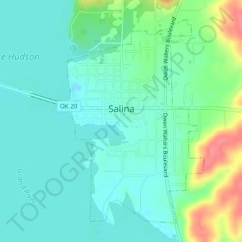
Name: Salina topographic map, elevation, terrain.

Location: Salina, Mayes County, Oklahoma, 74365, United States (36.28007 -95.16211 36.30274 -95.14187)

Average elevation: 663 ft

Minimum elevation: 604 ft

Maximum elevation: 830 ft

Mayes County trails, hiking, mountain biking, running and outdoor activities

Other topographic maps

Click on a map to view its topography, its elevation and its terrain.

Pryor Creek

United States > Oklahoma > Mayes County

Average elevation: 623 ft

Lusta

United States > Oklahoma > Mayes County

Average elevation: 623 ft

Pryor Creek

United States > Oklahoma > Mayes County

Average elevation: 623 ft

Gear up for your next adventure:

🛡️Insect Repellent - Protection against bugs during outdoor activities
🪶Wildlife Field Guides - Learn animal tracking and species ID
🥩Freeze-Dried Meals - Nutritious and lightweight food for remote expeditions
📷Action Cameras - Rugged cameras to document your journeys across rugged terrain
🥾Men's Hiking Boots - Durable, waterproof footwear for rugged terrain and steep inclines

As an Amazon Associate, this site earns from qualifying purchases at no extra cost to you.