
Make a donation
Gear up for your next adventure:
As an Amazon Associate, this site earns from qualifying purchases at no extra cost to you.
Brittan Square topographic map
Click on the map to display elevation.
Make a donation
Gear up for your next adventure:
As an Amazon Associate, this site earns from qualifying purchases at no extra cost to you.
About this map
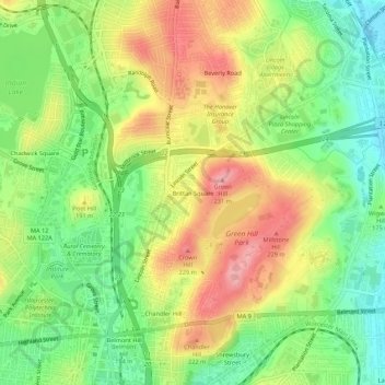
Name: Brittan Square topographic map, elevation, terrain.
Average elevation: 571 ft
Minimum elevation: 384 ft
Maximum elevation: 787 ft
Make a donation
Gear up for your next adventure:
As an Amazon Associate, this site earns from qualifying purchases at no extra cost to you.
Other topographic maps
Click on a map to view its topography, its elevation and its terrain.
Hadwen Park
United States > Massachusetts > Worcester County > Worcester > Heard Street
Average elevation: 545 ft
Institute Park
United States > Massachusetts > Worcester County > Worcester > Belmont Hill
Average elevation: 558 ft
Hadwen Arboretum
United States > Massachusetts > Worcester County > Worcester > Main South
Average elevation: 541 ft