Geolocate

Masherbrum (K1) topographic map

Click on the map to display elevation.

About this map

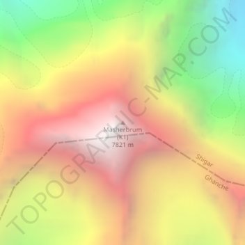
Name: Masherbrum (K1) topographic map, elevation, terrain.

Location: Masherbrum (K1), Gilgit-Baltistan, Pakistan (35.64333 76.30805 35.64343 76.30815)

Average elevation: 21,224 ft

Minimum elevation: 16,115 ft

Maximum elevation: 25,584 ft

Other topographic maps

Click on a map to view its topography, its elevation and its terrain.

Astore Tehsil

Pakistan > Gilgit-Baltistan > Astore District

Average elevation: 12,454 ft

Astore District

Pakistan > Gilgit-Baltistan

Average elevation: 12,231 ft

Hunza District

Pakistan > Gilgit-Baltistan

Average elevation: 14,797 ft

Hunza River

Pakistan > Gilgit-Baltistan > Minapin Nagar

Average elevation: 8,855 ft

Shigar River

Pakistan > Gilgit-Baltistan > Skardu

Average elevation: 9,465 ft

Gear up for your next adventure:

🚪Portable Camp Chair - Foldable chair for comfort at camp
📷Action Cameras - Rugged cameras to document your journeys across rugged terrain
🕶️GPS Smartphone Mount - Secure mount for phone navigation
📶Satellite Messenger - Communication device off‑grid
🕶️Glacier Sunglasses - Side shields to protect eyes from high-altitude snow glare

As an Amazon Associate, this site earns from qualifying purchases at no extra cost to you.