Geolocate

Gieten topographic map

Click on the map to display elevation.

About this map

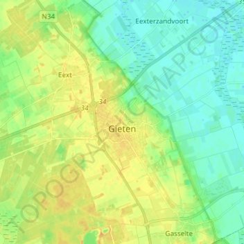
Name: Gieten topographic map, elevation, terrain.

Location: Gieten, Aa en Hunze, Drenthe, Netherlands (52.97163 6.70884 53.03890 6.83037)

Average elevation: 39 ft

Minimum elevation: 3 ft

Maximum elevation: 89 ft

Other topographic maps

Click on a map to view its topography, its elevation and its terrain.

Hondsrug

Netherlands > Drenthe > Exloo

Average elevation: 62 ft

Lhee

Netherlands > Drenthe

Average elevation: 36 ft

Zuidbarge

Netherlands > Drenthe > Emmen

Average elevation: 66 ft

Gear up for your next adventure:

🕶️Glacier Sunglasses - Side shields to protect eyes from high-altitude snow glare
🕶️GPS Smartphone Mount - Secure mount for phone navigation
🎒Trail Energy Bars - High‑calorie bars for hiking energy
💧Water Filtration Bottles - Safely drink from streams and lakes while exploring
🥾Women's Hiking Boots - Top-rated trail boots with ankle support and superior grip

As an Amazon Associate, this site earns from qualifying purchases at no extra cost to you.