Geolocate

Chone topographic map

Click on the map to display elevation.

About this map

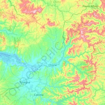
Name: Chone topographic map, elevation, terrain.

Location: Chone, Manabí, Ecuador (-0.79523 -80.14790 -0.47889 -79.62279)

Average elevation: 584 ft

Minimum elevation: -7 ft

Maximum elevation: 2,188 ft

Other topographic maps

Click on a map to view its topography, its elevation and its terrain.

Las Cujas

Ecuador > Manabí > Chone

Average elevation: 928 ft

Gear up for your next adventure:

🏔️Mountain Trail Maps - High‑detail maps for popular peaks
👓Polarized Sunglasses - Outdoor sunglasses for glare reduction
🧢Outdoor Hiking Hat - Sun protection hat for outdoor explorers
🥾Hiking Shoes - Durable and comfortable shoes for trail hiking
GPS Sports Watch - GPS watch for running, hiking and training

As an Amazon Associate, this site earns from qualifying purchases at no extra cost to you.