Geolocate

Benguet topographic map

Click on the map to display elevation.

Benguet

The province suffers from crop damage resulting from seasonal frost during the cold months of December to March, especially in high-altitude towns such as Atok, Buguias, Mankayan and Kibungan. In February 2007, Benguet suffered crop damage due to temperatures reaching as low as 7 °C (45 °F).

Wikipedia (CC-BY-SA 3.0)

About this map

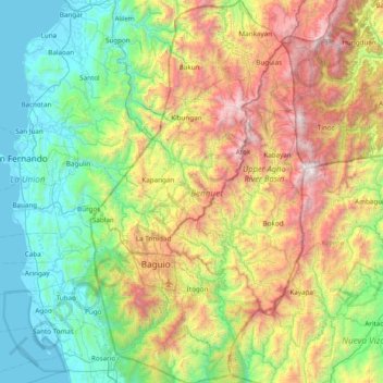
Name: Benguet topographic map, elevation, terrain.

Location: Benguet, Cordillera Administrative Region, Philippines (16.18100 120.46191 16.92044 120.89880)

Average elevation: 2,897 ft

Minimum elevation: -3 ft

Maximum elevation: 9,321 ft

Other topographic maps

Click on a map to view its topography, its elevation and its terrain.

Quezon City

Philippines

Founded as a pueblo by Saint Pedro Bautista in 1590, San Francisco del Monte may be considered Quezon City's oldest district. The original land area of the old town of San Francisco del Monte was approximately2.5 square kilometres (1.0 sq mi) and covered parts of what is currently known as Project 7 and 8 and…

Average elevation: 187 ft

Baguio

Philippines

In 1903, Filipinos, Japanese and Chinese workers were hired to build Kennon Road, the first road directly connecting Baguio with the lowlands of La Union and Pangasinan. Before this, the only road to Benguet was Naguilian Road, and it was largely a horse trail at higher elevations. Camp John Hay was…

Average elevation: 2,890 ft

Cebu City

Philippines > Cebu > Cebu City

Average elevation: 459 ft

Talomo District

Philippines > Davao City

Average elevation: 89 ft

Malico

Philippines > Nueva Vizcaya > San Nicolas

Average elevation: 4,285 ft

Cabadbaran

Philippines > Agusan del Norte

It is 29 kilometres (18 mi) from Butuan. It is generally flat with rolling hills and swamplands in its western part. The highest of all mountains in the Caraga region, Mount Hilong-Hilong (with an altitude of 2,012 metres (6,601 ft) above sea level), rises in this city.

Average elevation: 587 ft

Parañaque

Philippines

Average elevation: 46 ft

Bohol

Philippines

Average elevation: 381 ft

Aringay

Philippines > La Union > Aringay

Average elevation: 121 ft

Malainen Luma

Philippines > Cavite > Naic

Average elevation: 177 ft

Didicas Volcano

Philippines > Cagayan > Calayan

Didicas is topped with a lava dome with an elevation of 228 metres (748 ft) and a base diameter of 1,200 metres (3,900 ft) at sea level. It is at the southern end of the Luzon Volcanic Arc, and like all the volcanoes in the Philippines, is part of the Pacific ring of fire.

Average elevation: 23 ft

Mount Makiling

Philippines > Laguna > Los Baños

Average elevation: 1,073 ft

Iligan

Philippines

Average elevation: 751 ft

Mandaluyong

Philippines

Another claims that the Spaniards named the place based on the report of a navigator named Acapulco, who saw the rolling hills frequently being lashed at by daluyong (“big waves from the sea”). This seems to confirm traditional pre-Hispanic stories that giant waves from the sea would meet the adjoining…

Average elevation: 108 ft

Longlong

Philippines > Benguet > La Trinidad > Puguis

Average elevation: 4,478 ft

Koronadal Proper

Philippines > South Cotabato > Polomolok

Average elevation: 1,119 ft

Poro Point

Philippines > La Union > San Fernando

Average elevation: 7 ft

Pavia

Philippines > Iloilo

Average elevation: 52 ft

Calapan

Philippines > Oriental Mindoro

The overall land characteristic is a wide plain with rivers, interspersed with wetlands at the seacoast periphery. The highest elevation is 187 m (614 ft) above sea level at Bulusan Hill, a 6-kilometre (3.7 mi) long landform east of the city, which interrupts the mostly flat terrain north-east of the…

Average elevation: 131 ft

Davao City

Philippines

Average elevation: 184 ft

Aurora

Philippines > Zamboanga del Sur

Average elevation: 548 ft

Bongabong

Philippines > Oriental Mindoro

Average elevation: 36 ft

Maria Aurora

Philippines > Aurora

Average elevation: 177 ft

Davao City

Philippines

Average elevation: 213 ft

Talaingod

Philippines > Davao del Norte

Average elevation: 673 ft

Isabela

Philippines > Negros Occidental

Average elevation: 144 ft

Bulalacao

Philippines > Oriental Mindoro

Average elevation: 144 ft

General Tinio

Philippines > Nueva Ecija

Farming is the livelihood of majority of the residents. Even though located at the foot of the Sierra Madre Mountain Ridges, the topography is generally plain ideal to agricultural products such as palay and vegetables. A number of poultry broiler contract growers are located in the municipality. Other…

Average elevation: 177 ft

Sison

Philippines > Pangasinan

Average elevation: 407 ft

Surigao City

Philippines > Surigao Del Norte

Surigao City is marked by rolling hills that gently buffers its eastern and western boundaries. To the south-west towers the Kabangkaan Ridge which divides the city from the municipality of San Francisco (formerly Anao-aon). Kinabutan River (otherwise known as Surigao River) meanders Surigao valley before it…

Average elevation: 131 ft

Bacolod

Philippines

Bacólod (English: Bacolod), is derived from bakólod (Old Spelling: bacólod), the Old Hiligaynon (Old Ilonggo) (Old Spelling: Ylongo and Ilongo) word for a "hill, turtle, mound, rise, hillock, down, any small eminence or elevation", since the resettlement was founded on a stony, hilly area, now the barangay…

Average elevation: 161 ft

Batanes

Philippines

Average elevation: 85 ft

Cebu

Philippines

Average elevation: 292 ft

Villanueva

Philippines > Misamis Oriental

Average elevation: 279 ft

Olongapo

Philippines > Zambales > Olongapo

Average elevation: 636 ft

Butuan

Philippines

Average elevation: 377 ft

Irawan

Philippines > Puerto Princesa

Average elevation: 112 ft

Dominorog

Philippines > Bukidnon > Talakag

Average elevation: 3,917 ft

Sinocalan River

Philippines > Pangasinan > Urdaneta

Average elevation: 62 ft

Datu Danwata

Philippines > Davao Occidental

Average elevation: 2,572 ft

Agos River

Philippines > Quezon > Infanta > Pinaglapatan

Average elevation: 3 ft

Reserva

Philippines > Aurora > Baler

Average elevation: 23 ft

Salvacion

Philippines > Sorsogon

Average elevation: 52 ft

Rizal

Philippines

Average elevation: 312 ft

Molawin Creek

Philippines > Laguna > Los Baños

Average elevation: 52 ft

Cabog-cabog

Philippines > Bataan > Balanga

Average elevation: 456 ft

Panglao Island

Philippines > Bohol

Average elevation: 154 ft

Alfonso

Philippines > Cavite > Alfonso

Average elevation: 1,355 ft

Ormoc

Philippines > Leyte > Ormoc

Average elevation: 669 ft

Toledo

Philippines > Cebu

Average elevation: 351 ft

Valencia

Philippines > Bukidnon

The city's topography is characterized as flat to undulating hills with extensive plateaus and mountainous areas and cliffs on both eastern and western portions bounding the municipality of San Fernando on the east and the municipality of Talakag on the west. Its highest point is Mount Kalatungan in the…

Average elevation: 1,857 ft

San Pablo

Philippines > Laguna > San Pablo

Average elevation: 722 ft

Naguilian

Philippines > La Union

The approximate elevation of the municipality is 165 meters above sea level. It has the ninth highest approximate average elevation among the twenty (20) towns of the province. The portion with the highest elevation is 544 meters above sea level while the lowest is 10 meters. The slopes range from 2–7% in…

Average elevation: 279 ft

Panabo

Philippines > Davao del Norte > Panabo

Average elevation: 98 ft

Malolos

Philippines > Bulacan

Malolos is relatively flat of about 0.81% to a gently sloping of 2.17%. The slope of the land descends towards west, southwest to southern direction. The highest land elevation is at about 6.0 meters above sea level while the lowest is only half a meter below sea level. A network of natural waterways and…

Average elevation: 20 ft

San Juan

Philippines

"San Juan" is a contraction of the city's traditional name of "San Juan del Monte" (lit. 'Saint John of the Mountain'). As with numerous other places in the Philippines, the name combines a patron saint and a toponym; in this case Saint John the Baptist with the locale's hilly terrain and relatively higher…

Average elevation: 115 ft

Bauko

Philippines > Mountain Province

Average elevation: 4,442 ft

Passi

Philippines > Iloilo

Average elevation: 266 ft

Aramaywan

Philippines > Palawan

Average elevation: 59 ft

Baco

Philippines > Oriental Mindoro

Majority of the barangays of the municipality are in lowland areas or below 500 meters above sea level (MASL) and cover 41.88 percent of the total land area (13,035.58 ha). The three largest barangays, which cover most of the forestland, have an elevation that ranges from 500-1,000 and greater than 1,000…

Average elevation: 46 ft

Dasmariñas

Philippines > Cavite

Dasmariñas is partly lowland and partly hilly. The Poblacion itself is elevated. From an elevation of 80 meters (260 ft) at the Poblacion, the land rises to 250 meters (820 ft) towards Silang. Generally, land near rivers and creeks are rugged. Dasmariñas is outside the typhoon belt and has no fault line…

Average elevation: 318 ft

Kinatihan II

Philippines

Average elevation: 72 ft

Taboan River

Philippines > Cagayan

Average elevation: 755 ft

Pasig

Philippines

Average elevation: 151 ft

Quirino

Philippines

Average elevation: 354 ft

Legazpi

Philippines > Albay

Legazpi's topography is generally plain on the northeastern areas, with slopes ranging from five to fifteen degrees. The southern areas have mostly rolling to hilly terrain. In the city's coastal areas, the terrain varies from plain (north) to hilly (south). Legazpi is criss-crossed by several rivers including…

Average elevation: 492 ft

Tublay

Philippines > Benguet

According to the Philippine Statistics Authority, the municipality has a land area of 102.55 square kilometres (39.59 sq mi)  constituting 3.70% of the 2,769.08-square-kilometre- (1,069.15 sq mi) total area of Benguet. The topography is generally mountainous with an elevation of 1,400 metres (4,600 ft) above…

Average elevation: 4,121 ft

Tigbao

Philippines > Zamboanga del Sur

Average elevation: 1,345 ft

Paombong

Philippines > Bulacan

Average elevation: 10 ft

San Miguel

Philippines > Bulacan

Average elevation: 72 ft

Subic

Philippines > Zambales

Average elevation: 151 ft

Dauin

Philippines > Negros Oriental

Average elevation: 184 ft

Jasaan

Philippines > Misamis Oriental

Average elevation: 253 ft

Danao

Philippines > Cebu

Average elevation: 384 ft

Tagum

Philippines > Davao del Norte

One of the significant accomplishments of the officialdom of Tagum during the 1990s was its elevation from a second to the first-class municipality. This opened a gateway to increase its financial resources through the Internal Revenue Allocation (IRA) from the national government and local revenues. This was…

Average elevation: 338 ft

Virac

Philippines > Catanduanes

Average elevation: 249 ft

Marikina

Philippines

Average elevation: 262 ft

Patag Island

Philippines

Average elevation: 0 ft

Kota Island

Philippines

Average elevation: 0 ft

Lankiam Cay

Philippines

Average elevation: 0 ft

Iriga

Philippines

Average elevation: 377 ft

Davao Gulf

Philippines

Average elevation: 0 ft

Argao

Philippines > Cebu

Average elevation: 102 ft

Lawak Island

Philippines

Average elevation: 0 ft

Cabangan

Philippines > Zambales

The municipality has a varied topography characterized by high mountains to narrow coastal plains. The most outstanding feature observable in the municipality is the Zambales Range.

Average elevation: 171 ft

Surigao del Sur

Philippines

Average elevation: 899 ft

Candaba

Philippines

Average elevation: 20 ft

Ibabang Bukal

Philippines

Average elevation: 833 ft

Cabatang

Philippines

Average elevation: 1,099 ft

Mananga River

Philippines > Cebu > Talisay

Average elevation: 56 ft

Pinget

Philippines

Average elevation: 4,692 ft

Caloocan

Philippines

Average elevation: 266 ft

Aurora Hill North Central

Philippines

Average elevation: 4,852 ft

Besigan

Philippines

Average elevation: 1,916 ft

Talomo River

Philippines

Average elevation: 659 ft

Asin

Philippines

Average elevation: 4,334 ft

Catambungan

Philippines

Average elevation: 16 ft

Tablas Strait

Philippines

Average elevation: 0 ft

Buenavista

Philippines

Average elevation: 367 ft

Poliwes

Philippines

Average elevation: 4,583 ft

Gear up for your next adventure:

🌲Outdoor Survival Books - Best books on survival skills
🌐World Map Poster - Decorative world maps with topographic info
🦶Hiking Gaiters - Keep debris and water out of your boots
🏥Hiking First Aid Kits - Comprehensive medical kits for remote trail injuries
📱Heavy-Duty Phone Cases - Drop-proof and waterproof protection for outdoor navigation

As an Amazon Associate, this site earns from qualifying purchases at no extra cost to you.