
Make a donation
Gear up for your next adventure:
As an Amazon Associate, this site earns from qualifying purchases at no extra cost to you.
Madamba topographic map
Click on the map to display elevation.
Make a donation
Gear up for your next adventure:
As an Amazon Associate, this site earns from qualifying purchases at no extra cost to you.
About this map
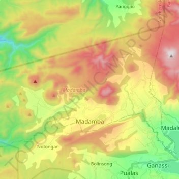
Name: Madamba topographic map, elevation, terrain.
Location: Madamba, Lanao del Sur, Bangsamoro, Philippines (7.83469 123.98117 7.92968 124.11571)
Average elevation: 3,615 ft
Minimum elevation: 1,598 ft
Maximum elevation: 6,020 ft
Make a donation
Gear up for your next adventure:
As an Amazon Associate, this site earns from qualifying purchases at no extra cost to you.
Other topographic maps
Click on a map to view its topography, its elevation and its terrain.
Wao
There are three possible etymology for the name of the municipality Wao. One is a local folklore which involved Bai Sa Raya, a Moro princess from a monarchy in Cotawato visited the area which is now known as "Wao" coincidentally during a serious drought. This led to the place to being called Wao from the word…
Average elevation: 1,959 ft
Make a donation
Gear up for your next adventure:
As an Amazon Associate, this site earns from qualifying purchases at no extra cost to you.
Amai Manabilang
Mountain ranges, hills, plateaus, and flatland characterize the topography of the barangay. It has a vast agricultural land suited for crops like rice, corn, carrots, sugar cane. Its hydrological features comprise rivers like the Maridugao and Sumogot, streams, swamps, creeks and springs.
Average elevation: 3,179 ft
Make a donation
Gear up for your next adventure:
As an Amazon Associate, this site earns from qualifying purchases at no extra cost to you.
Make a donation
Gear up for your next adventure:
As an Amazon Associate, this site earns from qualifying purchases at no extra cost to you.
Marawi
Marawi is located upon the shores of Lake Lanao. It is primarily inhabited by the Maranao people. The city is also called the "summer capital of the south" due to its higher elevation and cooler climate, a nickname it shares with Malaybalay.
Average elevation: 2,320 ft