
Kon Plông District topographic map
Interactive map
Click on the map to display elevation.
About this map
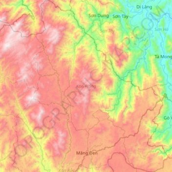
Name: Kon Plông District topographic map, elevation, terrain.
Location: Kon Plông District, Kon Tum province, Vietnam (14.54371 108.12504 15.06200 108.54710)
Average elevation: 3,123 ft
Minimum elevation: 118 ft
Maximum elevation: 6,545 ft
Other topographic maps
Click on a map to view its topography, its elevation and its terrain.
Sesan 4
Vietnam > Kon Tum province > Ia H'Drai District > Xã Ia Tơi
Sesan 4, Xã Ia Tơi, Ia H'Drai District, Kon Tum Province, Vietnam
Average elevation: 643 ft
Măng Đen
Vietnam > Kon Tum province > Kon Plông District
Măng Đen, Kon Plông District, Kon Tum Province, Vietnam
Average elevation: 3,711 ft
Kon Tum
Vietnam > Kon Tum province > Kon Tum City > Kon Tum
Kon Tum, Kon Tum City, Kon Tum province, 580000, Vietnam
Average elevation: 2,060 ft
Đắk Răng
Vietnam > Kon Tum province > Đắk Răng
Đắk Răng, Ngoc Hoi District, Kon Tum province, Vietnam
Average elevation: 2,680 ft
Tu Mơ Rông District
Tu Mơ Rông District, Kon Tum province, Vietnam
Average elevation: 4,209 ft