
Make a donation
Gear up for your next adventure:
As an Amazon Associate, this site earns from qualifying purchases at no extra cost to you.
Schrecksee topographic map
Click on the map to display elevation.
Make a donation
Gear up for your next adventure:
As an Amazon Associate, this site earns from qualifying purchases at no extra cost to you.
About this map
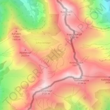
Name: Schrecksee topographic map, elevation, terrain.
Average elevation: 5,840 ft
Minimum elevation: 4,032 ft
Maximum elevation: 6,942 ft
Make a donation
Gear up for your next adventure:
As an Amazon Associate, this site earns from qualifying purchases at no extra cost to you.
Other topographic maps
Click on a map to view its topography, its elevation and its terrain.
Unterjoch
Deutschland > Bayern > Landkreis Oberallgäu > Bad Hindelang
Unterjoch ist ein Ortsteil des Marktes Bad Hindelang mit ungefähr 420 Einwohnern, der auf einer Höhe von 1013 m über NN liegt. Er ist heute touristisch geprägt.
Average elevation: 3,894 ft
Hintersteiner Tal
Deutschland > Bayern > Landkreis Oberallgäu > Bad Hindelang
Average elevation: 4,593 ft
Vorderhindelang
Deutschland > Bayern > Landkreis Oberallgäu > Bad Hindelang
Average elevation: 3,392 ft
Make a donation
Gear up for your next adventure:
As an Amazon Associate, this site earns from qualifying purchases at no extra cost to you.
Laufbacher Eck
Deutschland > Bayern > Landkreis Oberallgäu > Bad Hindelang
Das Laufbacher Eck ist ein 2178 m hoher Nebengipfel des Schnecks in den Allgäuer Alpen. Es hat den Charakter eines Grasbergs und liegt südöstlich des Lachenkopfs und nördlich des Rotkopfs, von dem er durch den Laufbacher-Eck-Sattel getrennt wird. Über diesen Sattel verläuft der Höhenweg vom…
Average elevation: 5,781 ft
Krummenbach
Deutschland > Bayern > Landkreis Oberallgäu > Bad Hindelang > Unterjoch
Average elevation: 3,717 ft
Make a donation
Gear up for your next adventure:
As an Amazon Associate, this site earns from qualifying purchases at no extra cost to you.
Untergschwend
Deutschland > Bayern > Landkreis Oberallgäu > Bad Hindelang > Unterjoch > Untergschwend
Average elevation: 3,888 ft
Make a donation
Gear up for your next adventure:
As an Amazon Associate, this site earns from qualifying purchases at no extra cost to you.