
Make a donation
Gear up for your next adventure:
As an Amazon Associate, this site earns from qualifying purchases at no extra cost to you.
Oostkamp topographic map
Click on the map to display elevation.
Make a donation
Gear up for your next adventure:
As an Amazon Associate, this site earns from qualifying purchases at no extra cost to you.
Oostkamp
Oostkamp ligt in Zandig Vlaanderen op een hoogte van ongeveer 10 meter. Een belangrijke waterloop die ten oosten van Oostkamp loopt is de Rivierbeek. Deze stroomt in noordelijke richting en komt bij het natuurgebied Warandeputten uit op het Kanaal Gent-Brugge, dat ten noordoosten van Oostkamp loopt. De relatief bosrijke omgeving (Doeveren, Kampveld, Munkebossen in het Bulskampveld) bleek aantrekkelijk voor de stichting van tal van kastelen en landgoederen.
Make a donation
Gear up for your next adventure:
As an Amazon Associate, this site earns from qualifying purchases at no extra cost to you.
About this map
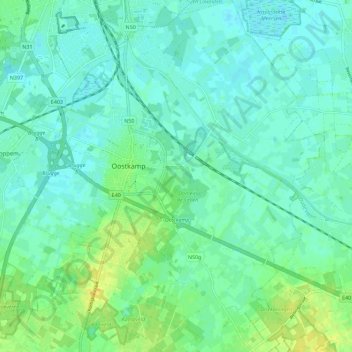
Name: Oostkamp topographic map, elevation, terrain.
Location: Oostkamp, Brugge, West-Vlaanderen, Vlaanderen, 8020, België (51.11573 3.19152 51.18646 3.29736)
Average elevation: 26 ft
Minimum elevation: 3 ft
Maximum elevation: 72 ft
Make a donation
Gear up for your next adventure:
As an Amazon Associate, this site earns from qualifying purchases at no extra cost to you.
Other topographic maps
Click on a map to view its topography, its elevation and its terrain.
Zedelgem
België > West-Vlaanderen > Brugge > Zedelgem
Zedelgem behoort tot Zandig Vlaanderen en de kom ligt op een hoogte van ongeveer 12 meter, terwijl de hoogte van de omgeving varieert van 9 tot 20 meter. De Plaatsebeek stroomt door het centrum en de Zabbeek stroomt iets ten noorden daarvan.
Average elevation: 39 ft
Make a donation
Gear up for your next adventure:
As an Amazon Associate, this site earns from qualifying purchases at no extra cost to you.
Wijnendale
België > West-Vlaanderen > Brugge > Torhout
Wijnendale ligt op het Plateau van Wijnendale, een plateau in landschap op ongeveer 40 meter hoogte, 20 meter hoger dan het lagere omliggende land.
Average elevation: 105 ft
Make a donation
Gear up for your next adventure:
As an Amazon Associate, this site earns from qualifying purchases at no extra cost to you.
Make a donation
Gear up for your next adventure:
As an Amazon Associate, this site earns from qualifying purchases at no extra cost to you.
Make a donation
Gear up for your next adventure:
As an Amazon Associate, this site earns from qualifying purchases at no extra cost to you.
Baliebrugge
België > West-Vlaanderen > Brugge
Baliebrugge ligt langs de weg van Ruddervoorde naar Torhout. Net ten westen van het gehucht loopt de autosnelweg A17/E403. De snelweg heeft ter hoogte van het gehucht wel een op- en afrit, maar de aansluiting loopt enkel in westelijke richting, richting Torhout. Vanuit Baliebrugge is er geen directe…
Average elevation: 59 ft
De Leeuw / Zuidwege / Sint-Elooi
België > West-Vlaanderen > Brugge > Zedelgem
Average elevation: 39 ft
Make a donation
Gear up for your next adventure:
As an Amazon Associate, this site earns from qualifying purchases at no extra cost to you.