
Make a donation
Gear up for your next adventure:
As an Amazon Associate, this site earns from qualifying purchases at no extra cost to you.
Chenango Forks topographic map
Click on the map to display elevation.
Make a donation
Gear up for your next adventure:
As an Amazon Associate, this site earns from qualifying purchases at no extra cost to you.
About this map
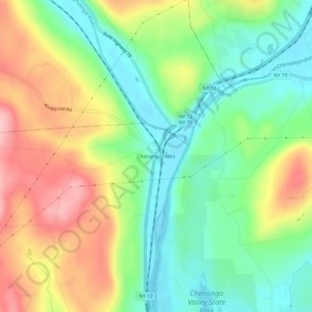
Name: Chenango Forks topographic map, elevation, terrain.
Average elevation: 1,096 ft
Minimum elevation: 866 ft
Maximum elevation: 1,421 ft
Broome County trails, hiking, mountain biking, running and outdoor activities
Make a donation
Gear up for your next adventure:
As an Amazon Associate, this site earns from qualifying purchases at no extra cost to you.
Other topographic maps
Click on a map to view its topography, its elevation and its terrain.
Kopernik Observatory & Science Center
United States > New York > Broome County > Town of Vestal > Tracy Creek
Average elevation: 1,483 ft
Make a donation
Gear up for your next adventure:
As an Amazon Associate, this site earns from qualifying purchases at no extra cost to you.
State University of New York at Binghamton
United States > New York > Broome County > Town of Vestal
Average elevation: 1,050 ft
Susquehanna River
United States > New York > Broome County > Town of Kirkwood
Average elevation: 1,348 ft
Make a donation
Gear up for your next adventure:
As an Amazon Associate, this site earns from qualifying purchases at no extra cost to you.
Make a donation
Gear up for your next adventure:
As an Amazon Associate, this site earns from qualifying purchases at no extra cost to you.