
Make a donation
Gear up for your next adventure:
As an Amazon Associate, this site earns from qualifying purchases at no extra cost to you.
Santa Fe topographic map
Click on the map to display elevation.
Make a donation
Gear up for your next adventure:
As an Amazon Associate, this site earns from qualifying purchases at no extra cost to you.
About this map
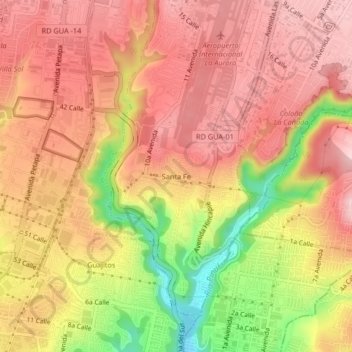
Name: Santa Fe topographic map, elevation, terrain.
Average elevation: 4,692 ft
Minimum elevation: 4,170 ft
Maximum elevation: 4,977 ft
Make a donation
Gear up for your next adventure:
As an Amazon Associate, this site earns from qualifying purchases at no extra cost to you.
Other topographic maps
Click on a map to view its topography, its elevation and its terrain.
Zona 7
Guatemala > Departamento de Guatemala > Ciudad de Guatemala > Colonia Villa de San Juan
Average elevation: 5,000 ft
Make a donation
Gear up for your next adventure:
As an Amazon Associate, this site earns from qualifying purchases at no extra cost to you.
Zona 4
Guatemala > Departamento de Guatemala > Ciudad de Guatemala > Zona 4
Average elevation: 4,931 ft
Parque de Jocotenango
Guatemala > Departamento de Guatemala > Ciudad de Guatemala
Average elevation: 4,820 ft
Make a donation
Gear up for your next adventure:
As an Amazon Associate, this site earns from qualifying purchases at no extra cost to you.
Corredor Avenida Reforma
Guatemala > Departamento de Guatemala > Ciudad de Guatemala
Average elevation: 4,934 ft
Parque Ecológico Ciudad Nueva
Guatemala > Departamento de Guatemala > Ciudad de Guatemala
Average elevation: 4,767 ft
Make a donation
Gear up for your next adventure:
As an Amazon Associate, this site earns from qualifying purchases at no extra cost to you.
Parque Navidad
Guatemala > Departamento de Guatemala > Ciudad de Guatemala
Average elevation: 4,843 ft
Zona 6
Guatemala > Departamento de Guatemala > Ciudad de Guatemala > Zona 6
Average elevation: 4,780 ft
Make a donation
Gear up for your next adventure:
As an Amazon Associate, this site earns from qualifying purchases at no extra cost to you.
Parque Ecológico Kanajuyú
Guatemala > Departamento de Guatemala > Ciudad de Guatemala > Zona 16
Average elevation: 5,010 ft
Parque Erick Barrondo
Guatemala > Departamento de Guatemala > Ciudad de Guatemala > Zona 7
Average elevation: 4,961 ft
Make a donation
Gear up for your next adventure:
As an Amazon Associate, this site earns from qualifying purchases at no extra cost to you.
Make a donation
Gear up for your next adventure:
As an Amazon Associate, this site earns from qualifying purchases at no extra cost to you.
Parque Minerva
Guatemala > Departamento de Guatemala > Ciudad de Guatemala
Average elevation: 4,734 ft
Centro Cultural Miguel Angel Asturias
Guatemala > Departamento de Guatemala > Ciudad de Guatemala
Average elevation: 4,928 ft
Make a donation
Gear up for your next adventure:
As an Amazon Associate, this site earns from qualifying purchases at no extra cost to you.
Parque Colón
Guatemala > Departamento de Guatemala > Ciudad de Guatemala > Zona 1
Average elevation: 4,879 ft
Plaza Vistas de San Isidro
Guatemala > Departamento de Guatemala > Ciudad de Guatemala
Average elevation: 5,364 ft
Make a donation
Gear up for your next adventure:
As an Amazon Associate, this site earns from qualifying purchases at no extra cost to you.
Make a donation
Gear up for your next adventure:
As an Amazon Associate, this site earns from qualifying purchases at no extra cost to you.
Make a donation
Gear up for your next adventure:
As an Amazon Associate, this site earns from qualifying purchases at no extra cost to you.
Make a donation
Gear up for your next adventure:
As an Amazon Associate, this site earns from qualifying purchases at no extra cost to you.
Make a donation
Gear up for your next adventure:
As an Amazon Associate, this site earns from qualifying purchases at no extra cost to you.
Plaza Berlín
Guatemala > Departamento de Guatemala > Ciudad de Guatemala > Santa Fe
Average elevation: 4,701 ft
Make a donation
Gear up for your next adventure:
As an Amazon Associate, this site earns from qualifying purchases at no extra cost to you.
Make a donation
Gear up for your next adventure:
As an Amazon Associate, this site earns from qualifying purchases at no extra cost to you.