
Make a donation
Gear up for your next adventure:
As an Amazon Associate, this site earns from qualifying purchases at no extra cost to you.
Melba topographic map
Click on the map to display elevation.
Make a donation
Gear up for your next adventure:
As an Amazon Associate, this site earns from qualifying purchases at no extra cost to you.
Melba
Melba is located at 43°22′25″N 116°31′45″W / 43.37361°N 116.52917°W / 43.37361; -116.52917 (43.373487, -116.529194). at an elevation of 2,667 feet (813 m) above sea level. It is 12 miles (19 km) south of Nampa, and three miles (5 km) northeast of the Snake River.
Make a donation
Gear up for your next adventure:
As an Amazon Associate, this site earns from qualifying purchases at no extra cost to you.
About this map
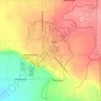
Name: Melba topographic map, elevation, terrain.
Location: Melba, Canyon County, Idaho, United States (43.36544 -116.54158 43.38086 -116.52360)
Average elevation: 2,618 ft
Minimum elevation: 2,405 ft
Maximum elevation: 2,746 ft
Canyon County trails, hiking, mountain biking, running and outdoor activities
Make a donation
Gear up for your next adventure:
As an Amazon Associate, this site earns from qualifying purchases at no extra cost to you.
Other topographic maps
Click on a map to view its topography, its elevation and its terrain.