
Make a donation
Gear up for your next adventure:
As an Amazon Associate, this site earns from qualifying purchases at no extra cost to you.
Haddon Heights topographic map
Click on the map to display elevation.
Make a donation
Gear up for your next adventure:
As an Amazon Associate, this site earns from qualifying purchases at no extra cost to you.
Haddon Heights
In 1890, Benjamin A. Lippincott constructed a passenger station in the center of his land for the Atlantic City Railroad. Then Lippincott, with Charles Hillman, filed a grid street plan with Camden County to develop a community. They named it Haddon Heights because of its proximity to Haddonfield and its high elevation. Large houses were built in Colonial Revival, Queen Anne or Foursquare style that appealed to prosperous middle-class families moving from the cities. In 1904, Haddon Heights was incorporated as a borough and Lippincott was elected mayor. A small downtown grew near the railroad and the White Horse Pike and eight churches and a synagogue were built. An area of old Centre Township, known as Fairfield Estates, voted in 1926 to become part of Haddon Heights. This land was developed for more single-family housing through the 1940s and 1950s. Even though rail passenger service was suspended in July 1965, Haddon Heights remains a typical turn-of-the-twentieth-century railroad suburb with tree-shaded streets and comfortable homes.
Make a donation
Gear up for your next adventure:
As an Amazon Associate, this site earns from qualifying purchases at no extra cost to you.
About this map
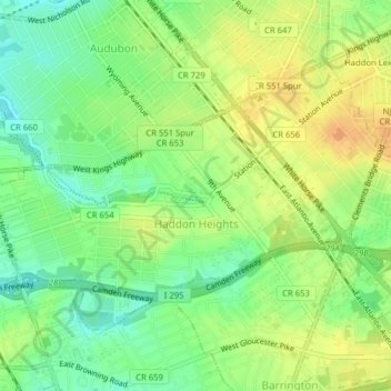
Name: Haddon Heights topographic map, elevation, terrain.
Average elevation: 66 ft
Minimum elevation: 10 ft
Maximum elevation: 115 ft
Make a donation
Gear up for your next adventure:
As an Amazon Associate, this site earns from qualifying purchases at no extra cost to you.
Other topographic maps
Click on a map to view its topography, its elevation and its terrain.
Downs Farms
United States > New Jersey > Camden County > Cherry Hill Township
Average elevation: 79 ft
Make a donation
Gear up for your next adventure:
As an Amazon Associate, this site earns from qualifying purchases at no extra cost to you.
Columbia Lakes
United States > New Jersey > Camden County > Cherry Hill Township
Average elevation: 56 ft
Charleston East
United States > New Jersey > Camden County > Cherry Hill Township
Average elevation: 75 ft
Make a donation
Gear up for your next adventure:
As an Amazon Associate, this site earns from qualifying purchases at no extra cost to you.
Haddon Towne
United States > New Jersey > Camden County > Cherry Hill Township
Average elevation: 66 ft
Stoys Landing
United States > New Jersey > Camden County > Cherry Hill Township
Average elevation: 46 ft
Make a donation
Gear up for your next adventure:
As an Amazon Associate, this site earns from qualifying purchases at no extra cost to you.
Andrews
United States > New Jersey > Camden County > Winslow Township > Sicklerville
Average elevation: 131 ft
Make a donation
Gear up for your next adventure:
As an Amazon Associate, this site earns from qualifying purchases at no extra cost to you.
Bishop Wood
United States > New Jersey > Camden County > Gloucester Township
Average elevation: 148 ft
Make a donation
Gear up for your next adventure:
As an Amazon Associate, this site earns from qualifying purchases at no extra cost to you.
West Collingswood
United States > New Jersey > Camden County > Haddon Township
Average elevation: 23 ft
Make a donation
Gear up for your next adventure:
As an Amazon Associate, this site earns from qualifying purchases at no extra cost to you.
Cherry Valley
United States > New Jersey > Camden County > Cherry Hill Township > Cherry Valley
Average elevation: 52 ft
Make a donation
Gear up for your next adventure:
As an Amazon Associate, this site earns from qualifying purchases at no extra cost to you.