Geolocate

Neosho topographic map

Click on the map to display elevation.

About this map

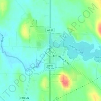
Name: Neosho topographic map, elevation, terrain.

Location: Neosho, Dodge County, Wisconsin, United States (43.30272 -88.52644 43.31915 -88.50947)

Average elevation: 915 ft

Minimum elevation: 860 ft

Maximum elevation: 1,070 ft

Dodge County trails, hiking, mountain biking, running and outdoor activities

Other topographic maps

Click on a map to view its topography, its elevation and its terrain.

Ashippun

United States > Wisconsin > Dodge County

Average elevation: 892 ft

Burnett

United States > Wisconsin > Dodge County

Average elevation: 892 ft

Rubicon

United States > Wisconsin > Dodge County

Average elevation: 1,040 ft

Lebanon

United States > Wisconsin > Dodge County

Average elevation: 912 ft

Gear up for your next adventure:

📚Navigation Handbooks - Master the art of reading topographic maps and using a compass
🔥Plasma Lighters - Windproof lighters that work in any weather condition
📌Outdoor GPS Map App - Apps and devices for digital topographic navigation
🌧️Backpack Rain Cover - Keep gear dry in wet weather
🔌USB Car Charger - Car charger for on‑the‑go power needs

As an Amazon Associate, this site earns from qualifying purchases at no extra cost to you.