
Roxborough topographic map
Click on the map to display elevation.
Roxborough
Since the 1950s, most of Philadelphia's major television and FM radio stations have located their transmission towers in Roxborough because of its hilly terrain and high elevation. The tallest of these towers, the American Tower, stands approximately 1,250 feet (381m) tall. Public television station "MiND", once called "WYBE", was also formerly located in Upper Roxborough, close to neighboring Andorra.
About this map
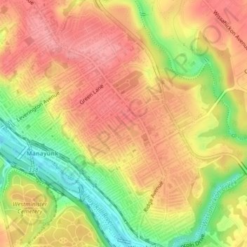
Name: Roxborough topographic map, elevation, terrain.
Average elevation: 207 ft
Minimum elevation: 16 ft
Maximum elevation: 322 ft
Philadelphia County trails, hiking, mountain biking, running and outdoor activities
Other topographic maps
Click on a map to view its topography, its elevation and its terrain.
Pastorius Park
United States > Pennsylvania > Philadelphia County > Philadelphia
Average elevation: 354 ft
Strawberry Mansion
United States > Pennsylvania > Philadelphia County > Philadelphia
Average elevation: 102 ft
East Passyunk Community Recreation Center
United States > Pennsylvania > Philadelphia County > Philadelphia
Average elevation: 30 ft
Bartram's Garden
United States > Pennsylvania > Philadelphia County > Philadelphia
Average elevation: 43 ft