
Sherman Island topographic map
Interactive map
Click on the map to display elevation.
About this map
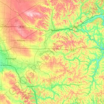
Name: Sherman Island topographic map, elevation, terrain.
Location: Sherman Island, Perry County, Ohio, 43076, USA (39.60368 -82.74460 40.24368 -82.10460)
Average elevation: 965 ft
Minimum elevation: 692 ft
Maximum elevation: 1,355 ft
Other topographic maps
Click on a map to view its topography, its elevation and its terrain.
Maumee River
Maumee River, Oregon, Lucas County, Ohio, 43434, USA
Average elevation: 584 ft
Ohio River
USA > Ohio > Cincinnati
Ohio River, East Pete Rose Way, Lytle Park Historic District, Mount Adams, Cincinnati, Hamilton County, Ohio, 45202, USA
Average elevation: 581 ft
Mount Adams
USA > Ohio > Cincinnati
Mount Adams, Cincinnati, Hamilton County, Ohio, 45202, USA
Average elevation: 594 ft
Wayne National Forest
Wayne National Forest, Old Forrest Ridge Road, Waterloo, Lawrence County, Ohio, 45688, USA
Average elevation: 827 ft
Cuyahoga River
USA > Ohio > Brecksville
Cuyahoga River, Brecksville, Sagamore Hills Township, Summit County, Ohio, 44264, USA
Average elevation: 896 ft
Lake Alma State Park
Lake Alma State Park, Puritan, Clinton Township, Vinton County, Ohio, 45634, USA
Average elevation: 761 ft
Clifton
USA > Ohio > Cincinnati
Clifton, Cincinnati, Hamilton County, Ohio, USA
Average elevation: 636 ft
Hueston Woods
USA > Ohio > Morning Sun
Hueston Woods, West Shore Trail, Morning Sun, Preble County, Ohio, 45003, USA
Average elevation: 948 ft
Bainbridge
USA > Ohio > Bainbridge
Bainbridge, Bainbridge Township, Geauga County, Ohio, 44023, USA
Average elevation: 1,115 ft
Continental
USA > Ohio > Continental
Continental, Putnam County, Ohio, 45831, USA
Average elevation: 722 ft
Woodland Mound
Woodland Mound, 8250, Eightmile, Hamilton County, Ohio, 45255, USA
Average elevation: 666 ft
The Heights
USA > Ohio > Cincinnati
The Heights, Cincinnati, Hamilton County, Ohio, USA
Average elevation: 722 ft
Big Darby Creek
Big Darby Creek, Brown Township, Madison County, Ohio, USA
Average elevation: 912 ft
Epworth Heights
USA > Ohio > Epworth Heights
Epworth Heights, Miami Township, Clermont County, Ohio, 45140, USA
Average elevation: 712 ft
Day Heights
USA > Ohio > Day Heights
Day Heights, Miami Township, Clermont County, Ohio, 45150, USA
Average elevation: 843 ft
Middletown Dam
USA > Ohio > Middletown
Middletown Dam, Middletown, Warren County, Ohio, 45042, USA
Average elevation: 679 ft
Russell Center
USA > Ohio > Russell Center
Russell Center, Russell Township, Geauga County, Ohio, 44072, USA
Average elevation: 1,109 ft
Corryville
USA > Ohio > Cincinnati
Corryville, Cincinnati, Hamilton County, Ohio, USA
Average elevation: 778 ft
Earls Island
USA > Ohio > Earls Island
Earls Island, Shelby County, Ohio, 45865, USA
Average elevation: 965 ft
Wildwood Preserve Metropark
USA > Ohio > Central Avenue Park
Wildwood Preserve Metropark, Central Avenue Park, Lucas County, Ohio, USA
Average elevation: 643 ft
Filson Park
USA > Ohio > Cincinnati
Filson Park, Prospect Hill Historic District, Prospect Hill, Cincinnati, Hamilton County, Ohio, USA
Average elevation: 676 ft
Olentangy River
Olentangy River, Richland Township, Marion County, Ohio, 43214:43220, USA
Average elevation: 1,030 ft
Charles Mill Lake
USA > Ohio > Mifflin Cottage Area
Charles Mill Lake, Schiago Trail, Mifflin Cottage Area, Mifflin Township, Ashland County, Ohio, 44805, USA
Average elevation: 1,089 ft
Cowan Lake
Cowan Lake, State Park Drive, Cuba, Clinton County, Ohio, 45114, USA
Average elevation: 1,004 ft
Wingfoot Lake
USA > Ohio > Suffield Station
Wingfoot Lake, Goodyear Park Boulevard, Suffield Station, Suffield Township, Portage County, Ohio, 44260, USA
Average elevation: 1,161 ft
Mentor Marsh State Nature Preserve
Mentor Marsh State Nature Preserve, Corduroy Road, Mentor, Lake County, Ohio, 44060, USA
Average elevation: 600 ft
Kokosing River
Kokosing River, Morris Township, Knox County, Ohio, 43050, USA
Average elevation: 1,181 ft
Metro Parks, Serving Summit County - Offices
Metro Parks, Serving Summit County - Offices, 975, Waters Edge, Merriman Valley, Akron, Summit County, Ohio, 44313, USA
Average elevation: 889 ft
Shade River
USA > Ohio > Shade River
Shade River, Meigs County, Ohio, 45743, USA
Average elevation: 699 ft
Maumee Bay
Maumee Bay, Lilias Drive, Oregon, Lucas County, Ohio, 43618, USA
Average elevation: 564 ft
Prattsville
USA > Ohio > Prattsville
Prattsville, Madison Township, Vinton County, Ohio, 45698, USA
Average elevation: 850 ft
South Shore Park
USA > Ohio > South Shore Park
South Shore Park, Lucas County, Ohio, 43618, USA
Average elevation: 577 ft
Goll Woods
Goll Woods, County Road G, Elmira, Fulton County, Ohio, 43502:43570, USA
Average elevation: 719 ft
Shanersville
USA > Ohio > Shanersville
Shanersville, Montgomery County, Ohio, 45449, USA
Average elevation: 932 ft
Stage's Pond State Nature Preserve
Stage's Pond State Nature Preserve, Ward Road, Walnut Township, Pickaway County, Ohio, 43103, USA
Average elevation: 715 ft