Geolocate

Mount Chase topographic map

Click on the map to display elevation.

About this map

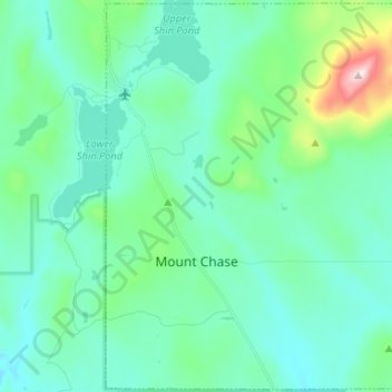
Name: Mount Chase topographic map, elevation, terrain.

Location: Mount Chase, Penobscot County, Maine, United States (46.03523 -68.56357 46.12513 -68.43227)

Average elevation: 945 ft

Minimum elevation: 643 ft

Maximum elevation: 2,411 ft

Penobscot County trails, hiking, mountain biking, running and outdoor activities

Other topographic maps

Click on a map to view its topography, its elevation and its terrain.

Lincoln

United States > Maine > Penobscot County > Lincoln

Average elevation: 272 ft

Houston Island

United States > Maine > Penobscot County > Winn

Average elevation: 243 ft

Carroll

United States > Maine > Penobscot County

Average elevation: 778 ft

Fairmont Park

United States > Maine > Penobscot County > Bangor

Average elevation: 148 ft

Meadow Brook

United States > Maine > Penobscot County

Average elevation: 325 ft

Gear up for your next adventure:

🏥Hiking First Aid Kits - Comprehensive medical kits for remote trail injuries
🚗GPS Dash Cams - Record your scenic drives through mountain passes and canyons
👟Trail Running Shoes - Lightweight shoes for trail runners
📚USA Hiking Guide Books - Top trail guides and map books
🥇GPS Hiking Watch - Multi‑sport GPS watch with navigation and trail tracking

As an Amazon Associate, this site earns from qualifying purchases at no extra cost to you.