Geolocate

Kirkpatrick topographic map

Click on the map to display elevation.

About this map
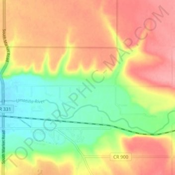
Name: Kirkpatrick topographic map, elevation, terrain.

Location: Kirkpatrick, Umatilla County, Oregon, United States (45.66606 -118.68472 45.69025 -118.62031)

Average elevation: 1,381 ft

Minimum elevation: 1,211 ft

Maximum elevation: 1,532 ft

Other topographic maps

Click on a map to view its topography, its elevation and its terrain.
Meacham

United States > Oregon > Umatilla County

Average elevation: 3,825 ft

Tollgate

United States > Oregon > Umatilla County

Average elevation: 4,961 ft

Myrick

United States > Oregon > Umatilla County

Average elevation: 1,755 ft

Cabbage Hill

United States > Oregon > Umatilla County

Average elevation: 3,330 ft

Hinkle

United States > Oregon > Umatilla County

Average elevation: 584 ft

Wallula Gap

United States > Oregon > Umatilla County

Average elevation: 1,027 ft

Nolin

United States > Oregon > Umatilla County

Average elevation: 968 ft

Gear up for your next adventure:

🧭Outdoor Navigation Book - Learn advanced navigation skills
🚗GPS Dash Cams - Record your scenic drives through mountain passes and canyons
🔋Rechargeable Batteries - Power up your outdoor devices
📌Outdoor GPS Map App - Apps and devices for digital topographic navigation
🎒Outdoor Daypacks - Lightweight backpacks designed for carrying maps and essential gear

As an Amazon Associate, this site earns from qualifying purchases at no extra cost to you.