Geolocate

Pratten Park topographic map

Click on the map to display elevation.

About this map

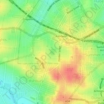
Name: Pratten Park topographic map, elevation, terrain.

Location: Pratten Park, Ashfield, Inner West, Sydney, Inner West Council, New South Wales, 2131, Australia (-33.89363 151.12200 -33.89174 151.12403)

Average elevation: 95 ft

Minimum elevation: 3 ft

Maximum elevation: 187 ft

Other topographic maps

Click on a map to view its topography, its elevation and its terrain.

Northern Beaches

Australia > New South Wales > Sydney

Average elevation: 220 ft

North Sydney

Australia > New South Wales > Sydney

Average elevation: 164 ft

Marsden Park

Australia > New South Wales > Sydney

Average elevation: 102 ft

Scotland Island

Australia > New South Wales > Sydney

Average elevation: 56 ft

Carlingford

Australia > New South Wales > Sydney

Average elevation: 322 ft

Cronulla

Australia > New South Wales > Sydney

Average elevation: 26 ft

Beecroft

Australia > New South Wales > Sydney

Average elevation: 410 ft

Bondi Beach

Australia > New South Wales > Sydney

Average elevation: 102 ft

Hornsby

Australia > New South Wales > Sydney

Average elevation: 525 ft

Lane Cove National Park

Australia > New South Wales > Sydney

The park includes areas of land which are part of Ku-ring-gai, Ryde, and Hornsby local government areas with small areas of the park in Willoughby, Lane Cove and Hunter's Hill local government areas on the banks of the lower reaches of the river. The park is surrounded on all sides by developed suburban areas…

Average elevation: 266 ft

Penrith

Australia > New South Wales > Sydney > Penrith

Penrith is a city in New South Wales, Australia, located in Greater Western Sydney, 55 kilometres (31 mi) west of the Sydney central business district on the banks of the Nepean River, on the outskirts of the Cumberland Plain. Its elevation is 32 metres (105 ft).

Average elevation: 112 ft

Berowra

Australia > New South Wales > Sydney

Berowra is located 44 kilometres north of the Sydney CBD and lies at an altitude of 215 metres. Surrounded by bushland, it borders the national parks of both the Berowra Valley and Ku-ring-gai Chase.

Average elevation: 472 ft

Sydney

Australia > New South Wales > Sydney

Average elevation: 75 ft

The Rocks

Australia > New South Wales > Sydney

Average elevation: 46 ft

Mosman

Australia > New South Wales > Sydney

Average elevation: 95 ft

Killara

Australia > New South Wales > Sydney

Average elevation: 282 ft

Frenchs Forest

Australia > New South Wales > Sydney

Average elevation: 361 ft

The Ponds

Australia > New South Wales > Sydney

Average elevation: 197 ft

Moore Park

Australia > New South Wales > Sydney

Average elevation: 141 ft

Mount Colah

Australia > New South Wales > Sydney

Mount Colah is 5 km north of Hornsby, the nearest major town centre. It is one of the most northerly suburbs of Sydney and is where the "Welcome to Sydney" sign is located. Mount Colah is the second highest suburb in Sydney by elevation. Considered one of Sydney's leafier suburbs, streets are clustered around…

Average elevation: 499 ft

Collaroy Plateau

Australia > New South Wales > Sydney

Average elevation: 98 ft

Waterfall

Australia > New South Wales > Sydney

Average elevation: 584 ft

Sydney CBD

Australia > New South Wales > Sydney

Average elevation: 82 ft

Centennial Park

Australia > New South Wales > Sydney

Average elevation: 167 ft

Rozelle

Australia > New South Wales > Sydney

Average elevation: 52 ft

Warriewood

Australia > New South Wales > Sydney

Average elevation: 108 ft

Upper North Shore

Australia > New South Wales > Sydney

Average elevation: 390 ft

Canterbury-Bankstown Council

Australia > New South Wales > Sydney

Within the same year 16 US fighter planes that were based at Bankstown airport flew over Canterbury racecourse at low altitude during a race meet. This was to let the Australian public, especially those of the district to know that they, their allies were there for their protection. Regardless of these events,…

Average elevation: 85 ft

Darlinghurst

Australia > New South Wales > Sydney

Average elevation: 125 ft

Randwick

Australia > New South Wales > Sydney

Average elevation: 144 ft

Bronte

Australia > New South Wales > Sydney

Average elevation: 138 ft

Seaforth

Australia > New South Wales > Sydney

Average elevation: 161 ft

Botany Bay

Australia > New South Wales > Sydney

Average elevation: 26 ft

Palm Beach

Australia > New South Wales > Sydney

Average elevation: 43 ft

Brighton-Le-Sands

Australia > New South Wales > Sydney

Average elevation: 20 ft

Earlwood

Australia > New South Wales > Sydney

Average elevation: 75 ft

West Pymble

Australia > New South Wales > Sydney

Average elevation: 220 ft

Marrickville

Australia > New South Wales > Sydney

Average elevation: 56 ft

Ryde

Australia > New South Wales > Sydney

Average elevation: 171 ft

Lane Cove

Australia > New South Wales > Sydney

Average elevation: 171 ft

Ku-ring-gai Chase National Park

Australia > New South Wales > Sydney

Ku-ring-gai Chase is part of the Hornsby Plateau, a massive block of sandstone tilting upwards to the north. The park comprises a plateau with an elevation of generally 150–200 m above sea level. Between 250 and 200 million years ago, sand silt and mud was deposited by rivers across flood plains. These…

Average elevation: 272 ft

Hunters Hill

Australia > New South Wales > Sydney

Average elevation: 79 ft

Lane Cove River

Australia > New South Wales > Sydney

Average elevation: 154 ft

Emu Heights

Australia > New South Wales > Sydney

Average elevation: 285 ft

North Ryde

Australia > New South Wales > Sydney

Average elevation: 171 ft

Mount Druitt

Australia > New South Wales > Sydney

Average elevation: 171 ft

Engadine

Australia > New South Wales > Sydney

Average elevation: 397 ft

Cabramatta

Australia > New South Wales > Sydney

Average elevation: 52 ft

Parramatta River

Australia > New South Wales > Sydney > Parramatta

Average elevation: 141 ft

Echo Point

Australia > New South Wales > Sydney

Average elevation: 2,379 ft

Lower North Shore

Australia > New South Wales > Sydney

Average elevation: 148 ft

Inner West

Australia > New South Wales > Sydney

Average elevation: 62 ft

Port Jackson

Australia > New South Wales > Sydney

Average elevation: 102 ft

Waverton

Australia > New South Wales > Sydney

Average elevation: 108 ft

Schofields

Australia > New South Wales > Sydney

Average elevation: 105 ft

Warragamba

Australia > New South Wales > Sydney

Average elevation: 515 ft

Windsor

Australia > New South Wales > Sydney

Average elevation: 39 ft

Barangaroo

Australia > New South Wales > Sydney

Average elevation: 49 ft

Oatley

Australia > New South Wales > Sydney

Average elevation: 79 ft

Glenmore Park

Australia > New South Wales > Sydney

Average elevation: 177 ft

Balgowlah Heights

Australia > New South Wales > Sydney

Average elevation: 82 ft

Glenorie

Australia > New South Wales > Sydney

Average elevation: 430 ft

Casula

Australia > New South Wales > Sydney

Casula is the first suburb immediately south of Liverpool on the Hume Highway and the Main Southern railway line between Sydney and Melbourne. Casula consists of undulating, gently rolling land, with elevations across the suburb being mostly between 30 and 70 metres above sea level. The Georges River forms the…

Average elevation: 112 ft

Zetland

Australia > New South Wales > Sydney

Average elevation: 85 ft

Emu Plains

Australia > New South Wales > Sydney > Penrith

Average elevation: 89 ft

Potts Point

Australia > New South Wales > Sydney

Average elevation: 52 ft

Padstow Heights

Australia > New South Wales > Sydney

Average elevation: 85 ft

Hurlstone Park

Australia > New South Wales > Sydney

Average elevation: 79 ft

Castle Hill

Australia > New South Wales > Sydney

Average elevation: 404 ft

Box Hill

Australia > New South Wales > Sydney

Average elevation: 148 ft

Kurrajong

Australia > New South Wales > Sydney

Average elevation: 801 ft

Cherrybrook

Australia > New South Wales > Sydney

Average elevation: 522 ft

Blaxlands Ridge

Australia > New South Wales > Sydney

Average elevation: 243 ft

Whites Creek

Australia > New South Wales > Sydney

Average elevation: 75 ft

Gunnamatta Bay

Australia > New South Wales > Sydney

Average elevation: 30 ft

St George

Australia > New South Wales > Sydney

Average elevation: 82 ft

Fairfield

Australia > New South Wales > Sydney

Average elevation: 59 ft

Beacon Hill

Australia > New South Wales > Sydney

Average elevation: 302 ft

Glebe Point

Australia > New South Wales > Sydney

Average elevation: 56 ft

Woronora

Australia > New South Wales > Sydney

Woronora Plateau, is a geographical region adjacent to the Sydney Plain. Slightly higher in altitude, it is capped with Hawkesbury Sandstone. The Woronora River flows through the deeply dissected plateau to the Georges River from near the sources of the Port Hacking, within the Sutherland Shire.

Average elevation: 213 ft

Bullaburra

Australia > New South Wales > Sydney

By 1986, Bruce's Walk had come to the attention of two other walkers, Jim Smith and Wilf Hilder, who organised a group of volunteers to clear the track between Bullaburra and Wentworth Falls. In the process, they found many artefacts and features, including signs, shelter caves, seats and picnic tables. This…

Average elevation: 2,336 ft

Alfords Point

Australia > New South Wales > Sydney

Average elevation: 138 ft

Woodford

Australia > New South Wales > Sydney

Woodford is a village in the Blue Mountains in New South Wales, Australia, about 90 kilometres west of Sydney. Its elevation is 609 metres (1,998 ft) above sea level. It is situated on the Great Western Highway and has a railway station (opened in 1868 as Buss's Platform) on the Main Western railway line…

Average elevation: 1,785 ft

Hurstville

Australia > New South Wales > Sydney

Average elevation: 164 ft

Rockdale

Australia > New South Wales > Sydney

Average elevation: 66 ft

Bella Vista

Australia > New South Wales > Sydney

Average elevation: 259 ft

Berkshire Park

Australia > New South Wales > Sydney

Average elevation: 89 ft

St Leonards

Australia > New South Wales > Sydney

Average elevation: 226 ft

Denistone West

Australia > New South Wales > Sydney

Average elevation: 180 ft

Parsley Bay

Australia > New South Wales > Sydney > Brooklyn

Average elevation: 66 ft

Nelson

Australia > New South Wales > Sydney

Average elevation: 154 ft

Beaconsfield

Australia > New South Wales > Sydney

Average elevation: 59 ft

Peak Hill

Australia > New South Wales > Sydney

Average elevation: 190 ft

Smithfield

Australia > New South Wales > Sydney

Established in 1836, Smithfield was the first major settlement of the Fairfield LGA. The original 1838 summary plan of Smithfield shows the suburb laid out in a grid pattern with most of the streets having the same names as they do today. Its altitude ranges from 21 to 48 m (69 to 157 ft) above sea level.…

Average elevation: 108 ft

Cronulla Point

Australia > New South Wales > Sydney

Average elevation: 23 ft

Holroyd

Australia > New South Wales > Sydney

Average elevation: 79 ft

Richmond Lowlands

Australia > New South Wales > Sydney

Average elevation: 43 ft

Oyster Bay

Australia > New South Wales > Sydney

Average elevation: 82 ft

Killarney Heights

Australia > New South Wales > Sydney

Average elevation: 236 ft

North Curl Curl

Australia > New South Wales > Sydney

Average elevation: 72 ft

Gear up for your next adventure:

🏥Hiking First Aid Kits - Comprehensive medical kits for remote trail injuries
🛠️Outdoor Gear Repair Kit - Essential tools to fix gear on the trail
🧭Hiking Compass - Precision compass for reliable navigation in the wilderness
🎒Waterproof Dry Bags - Keep your electronics and maps dry inside your pack
📻Weather Alert Radios - Stay informed of storm risks while off-the-grid

As an Amazon Associate, this site earns from qualifying purchases at no extra cost to you.