
Make a donation
Gear up for your next adventure:
As an Amazon Associate, this site earns from qualifying purchases at no extra cost to you.
Onota Township topographic map
Click on the map to display elevation.
Make a donation
Gear up for your next adventure:
As an Amazon Associate, this site earns from qualifying purchases at no extra cost to you.
About this map
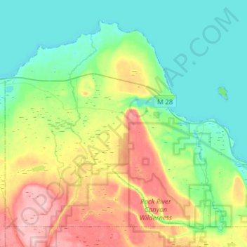
Name: Onota Township topographic map, elevation, terrain.
Location: Onota Township, Alger County, Michigan, 49822, United States (46.39097 -87.11652 46.53516 -86.86598)
Average elevation: 748 ft
Minimum elevation: 574 ft
Maximum elevation: 1,122 ft
Alger County trails, hiking, mountain biking, running and outdoor activities
Make a donation
Gear up for your next adventure:
As an Amazon Associate, this site earns from qualifying purchases at no extra cost to you.
Other topographic maps
Click on a map to view its topography, its elevation and its terrain.
Make a donation
Gear up for your next adventure:
As an Amazon Associate, this site earns from qualifying purchases at no extra cost to you.
Christmas
United States > Michigan > Alger County > Au Train Township > Christmas
Average elevation: 666 ft