Geolocate

Wilno topographic map

Click on the map to display elevation.

About this map
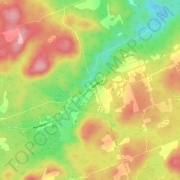
Name: Wilno topographic map, elevation, terrain.

Location: Wilno, Madawaska Valley, Renfrew County, Eastern Ontario, Ontario, K0J 2N0, Canada (45.49145 -77.58025 45.53145 -77.54025)

Average elevation: 1,089 ft

Minimum elevation: 751 ft

Maximum elevation: 1,391 ft

Other topographic maps

Click on a map to view its topography, its elevation and its terrain.

Bark Lake

Canada > Ontario > Renfrew County > Madawaska Valley

Average elevation: 1,224 ft

Noonan Lake

Canada > Ontario > Renfrew County > Madawaska Valley

Average elevation: 984 ft

Stoney Lake

Canada > Ontario > Renfrew County > Madawaska Valley

Average elevation: 1,093 ft

Trout Lake

Canada > Ontario > Renfrew County > Madawaska Valley

Average elevation: 1,099 ft

Gear up for your next adventure:

🔦LED Headlamp - Bright and durable LED headlamp for night navigation
🥩Freeze-Dried Meals - Nutritious and lightweight food for remote expeditions
🧦Merino Wool Socks - Moisture-wicking, blister-preventing socks for long treks
🌎3D Topographic Globes - Raised relief globes for a tactile understanding of geography
🧣Hiking Neck Gaiter - Multi‑use neck protection for outdoor weather

As an Amazon Associate, this site earns from qualifying purchases at no extra cost to you.