
Make a donation
Gear up for your next adventure:
As an Amazon Associate, this site earns from qualifying purchases at no extra cost to you.
Brüggelchen topographic map
Click on the map to display elevation.
Make a donation
Gear up for your next adventure:
As an Amazon Associate, this site earns from qualifying purchases at no extra cost to you.
About this map
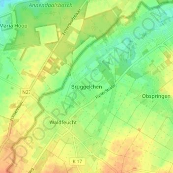
Name: Brüggelchen topographic map, elevation, terrain.
Average elevation: 164 ft
Minimum elevation: 102 ft
Maximum elevation: 220 ft
Make a donation
Gear up for your next adventure:
As an Amazon Associate, this site earns from qualifying purchases at no extra cost to you.
Other topographic maps
Click on a map to view its topography, its elevation and its terrain.
Erkelenz
Germany > North Rhine-Westphalia > Kreis Heinsberg
Soon after its elevation to town status, work began on the brick fortifications of the place. These probably consisted of basic ramparts as had been common since time immemorial for the defence of settlements, which had been started in the 11th century. Although the castle was not documented until 1349, the…
Average elevation: 272 ft
Make a donation
Gear up for your next adventure:
As an Amazon Associate, this site earns from qualifying purchases at no extra cost to you.