
Make a donation
Gear up for your next adventure:
As an Amazon Associate, this site earns from qualifying purchases at no extra cost to you.
Erkelenz topographic map
Click on the map to display elevation.
Make a donation
Gear up for your next adventure:
As an Amazon Associate, this site earns from qualifying purchases at no extra cost to you.
Erkelenz
Soon after its elevation to town status, work began on the brick fortifications of the place. These probably consisted of basic ramparts as had been common since time immemorial for the defence of settlements, which had been started in the 11th century. Although the castle was not documented until 1349, the town appeared to have developed under the protection of the castle along the Pangel, the oldest mentioned street (in deme Pandale, 1398) which was in its immediate vicinity. The nearby Johannismarkt (alder mart , Engl.: old market, 1420) and the more distant square known today simply as Markt ("market"), then referred to as the niewer mart (Engl.: new market, 1480), were also mentioned. In addition the castle had clearly been built within the town walls, so that it must have been there at least when town rights were granted in 1326. It is also hardly likely that an undefended place would have been elevated to the status of a town. Finally, the first and strongest town gateway, the Brück Gate (Brücktor, on Brückstraße) was built in 1355 on the Cologne Military Road (Kölner Heerbahn) that came from Roermond to Erkelenz and ran along the Theodor-Körner Road, Mühlenstraße and Wockerath to Cologne.
Make a donation
Gear up for your next adventure:
As an Amazon Associate, this site earns from qualifying purchases at no extra cost to you.
About this map
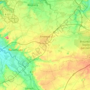
Name: Erkelenz topographic map, elevation, terrain.
Average elevation: 272 ft
Minimum elevation: 138 ft
Maximum elevation: 492 ft
Make a donation
Gear up for your next adventure:
As an Amazon Associate, this site earns from qualifying purchases at no extra cost to you.
Other topographic maps
Click on a map to view its topography, its elevation and its terrain.
Kleingladbach
Germany > North Rhine-Westphalia > Kreis Heinsberg > Hückelhoven
Average elevation: 276 ft
Wahnenbusch
Germany > North Rhine-Westphalia > Kreis Heinsberg > Erkelenz > Tenholt
Average elevation: 308 ft
Watern
Germany > North Rhine-Westphalia > Kreis Heinsberg > Wegberg > Klinkum
Average elevation: 253 ft
Make a donation
Gear up for your next adventure:
As an Amazon Associate, this site earns from qualifying purchases at no extra cost to you.
Auf dem Wengel
Germany > North Rhine-Westphalia > Kreis Heinsberg > Wegberg > Büch
Average elevation: 259 ft
Make a donation
Gear up for your next adventure:
As an Amazon Associate, this site earns from qualifying purchases at no extra cost to you.
Rödgen
Germany > North Rhine-Westphalia > Kreis Heinsberg > Wegberg > Rödgen
Average elevation: 249 ft
Hückelhoven
Germany > North Rhine-Westphalia > Kreis Heinsberg > Hückelhoven > Hückelhoven
Average elevation: 226 ft
Make a donation
Gear up for your next adventure:
As an Amazon Associate, this site earns from qualifying purchases at no extra cost to you.