
Make a donation
Gear up for your next adventure:
As an Amazon Associate, this site earns from qualifying purchases at no extra cost to you.
La Vernaz topographic map
Click on the map to display elevation.
Make a donation
Gear up for your next adventure:
As an Amazon Associate, this site earns from qualifying purchases at no extra cost to you.
About this map
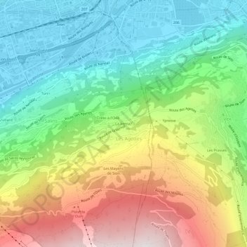
Name: La Vernaz topographic map, elevation, terrain.
Location: La Vernaz, Les Agettes, Sion, Valais, 1992, Suisse (46.19059 7.35404 46.23059 7.39404)
Average elevation: 3,241 ft
Minimum elevation: 1,575 ft
Maximum elevation: 5,991 ft
Make a donation
Gear up for your next adventure:
As an Amazon Associate, this site earns from qualifying purchases at no extra cost to you.
Other topographic maps
Click on a map to view its topography, its elevation and its terrain.
Les Agettes
Suisse > Valais > Sion > Sion > Les Agettes
Les Agettes est une ancienne commune suisse du canton du Valais, située dans le district de Sion entre 980 et 2 200 mètres d'altitude.
Average elevation: 4,577 ft