
Make a donation
Gear up for your next adventure:
As an Amazon Associate, this site earns from qualifying purchases at no extra cost to you.
Stony Rapids topographic map
Click on the map to display elevation.
Make a donation
Gear up for your next adventure:
As an Amazon Associate, this site earns from qualifying purchases at no extra cost to you.
About this map
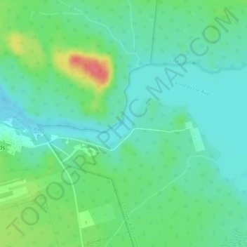
Name: Stony Rapids topographic map, elevation, terrain.
Average elevation: 745 ft
Minimum elevation: 686 ft
Maximum elevation: 892 ft
Make a donation
Gear up for your next adventure:
As an Amazon Associate, this site earns from qualifying purchases at no extra cost to you.
Other topographic maps
Click on a map to view its topography, its elevation and its terrain.
Morin Lake
Canada > Saskatchewan > Northern Saskatchewan Administration District > Morin Lake
Average elevation: 1,263 ft
Black Lake
Canada > Saskatchewan > Northern Saskatchewan Administration District > Black Lake
Average elevation: 961 ft
La Loche
Canada > Saskatchewan > Northern Saskatchewan Administration District > La Loche
Average elevation: 1,467 ft
Air Ronge
Canada > Saskatchewan > Northern Saskatchewan Administration District > Air Ronge
Average elevation: 1,211 ft
Make a donation
Gear up for your next adventure:
As an Amazon Associate, this site earns from qualifying purchases at no extra cost to you.
Garson Lake
Canada > Saskatchewan > Northern Saskatchewan Administration District > Garson Lake
Average elevation: 1,542 ft
Hall Lake
Canada > Saskatchewan > Northern Saskatchewan Administration District > Hall Lake
Average elevation: 1,283 ft
Doré Lake
Canada > Saskatchewan > Northern Saskatchewan Administration District
Average elevation: 1,558 ft