
Make a donation
Gear up for your next adventure:
As an Amazon Associate, this site earns from qualifying purchases at no extra cost to you.
Port Williams topographic map
Click on the map to display elevation.
Make a donation
Gear up for your next adventure:
As an Amazon Associate, this site earns from qualifying purchases at no extra cost to you.
About this map
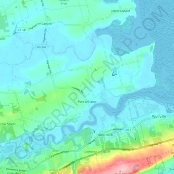
Name: Port Williams topographic map, elevation, terrain.
Average elevation: 79 ft
Minimum elevation: -10 ft
Maximum elevation: 522 ft
Make a donation
Gear up for your next adventure:
As an Amazon Associate, this site earns from qualifying purchases at no extra cost to you.
Other topographic maps
Click on a map to view its topography, its elevation and its terrain.
Annapolis Valley
Canada > Nova Scotia > Municipality of the County of Kings > Auburn
Average elevation: 253 ft
Loon Lake Channel
Canada > Nova Scotia > Municipality of the County of Kings > Aylesford Lake
Average elevation: 722 ft
Starrs Point
Canada > Nova Scotia > Municipality of the County of Kings > Port Williams
Average elevation: 10 ft
Cape Split
Canada > Nova Scotia > Municipality of the County of Kings > Scots Bay
Average elevation: 20 ft
Make a donation
Gear up for your next adventure:
As an Amazon Associate, this site earns from qualifying purchases at no extra cost to you.
Gaspereau Mountain
Canada > Nova Scotia > Municipality of the County of Kings > Forest Hill
Average elevation: 607 ft
Gaspereau
Canada > Nova Scotia > Municipality of the County of Kings > Gaspereau
Average elevation: 312 ft