
Sanford topographic map
Click on the map to display elevation.
Sanford
Sanford is located at 43°26′23″N 70°46′23″W / 43.43972°N 70.77306°W / 43.43972; -70.77306 (43.439925, −70.773304). According to the United States Census Bureau, the city has a total area of 48.75 square miles (126.26 km2), of which, 47.78 square miles (123.75 km2) of it is land and 0.97 square miles (2.51 km2) is water. Located near foothills, Sanford is drained by the Mousam River. Mt. Hope, elevation 680 feet (207 m) above sea level, is the city's highest point. The lowest elevation, which is approximately 140 feet (42.7 m) above sea level, is on the Mousam River at Old Falls Pond as it flows into Kennebunk.
About this map
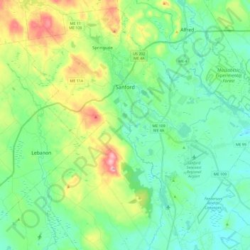
Name: Sanford topographic map, elevation, terrain.
Location: Sanford, York County, Maine, United States (43.33490 -70.87207 43.49164 -70.64261)
Average elevation: 338 ft
Minimum elevation: 148 ft
Maximum elevation: 843 ft
York County trails, hiking, mountain biking, running and outdoor activities
Other topographic maps
Click on a map to view its topography, its elevation and its terrain.