
Southlake topographic map
Click on the map to display elevation.
About this map
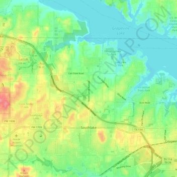
Name: Southlake topographic map, elevation, terrain.
Location: Southlake, Tarrant County, Texas, 76092, United States (32.91406 -97.20321 33.01110 -97.09866)
Average elevation: 610 ft
Minimum elevation: 522 ft
Maximum elevation: 761 ft
Tarrant County trails, hiking, mountain biking, running and outdoor activities
Other topographic maps
Click on a map to view its topography, its elevation and its terrain.
Will Rogers Memorial Center
United States > Texas > Tarrant County > Fort Worth
Average elevation: 594 ft