
Make a donation
Gear up for your next adventure:
As an Amazon Associate, this site earns from qualifying purchases at no extra cost to you.
Tshwane Ward 47 topographic map
Click on the map to display elevation.
Make a donation
Gear up for your next adventure:
As an Amazon Associate, this site earns from qualifying purchases at no extra cost to you.
About this map
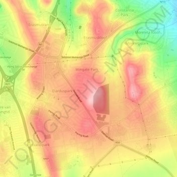
Name: Tshwane Ward 47 topographic map, elevation, terrain.
Average elevation: 4,997 ft
Minimum elevation: 4,656 ft
Maximum elevation: 5,213 ft
Make a donation
Gear up for your next adventure:
As an Amazon Associate, this site earns from qualifying purchases at no extra cost to you.
Other topographic maps
Click on a map to view its topography, its elevation and its terrain.
Faerie Glen
South Africa > Gauteng > City of Tshwane Metropolitan Municipality
Average elevation: 4,603 ft
Apies
South Africa > Gauteng > City of Tshwane Metropolitan Municipality > Pretoria
Average elevation: 4,101 ft
Roodeplaat Dam
South Africa > Gauteng > City of Tshwane Metropolitan Municipality
Average elevation: 4,068 ft
Faerie Glen Nature Reserve
South Africa > Gauteng > City of Tshwane Metropolitan Municipality > Pretoria
Average elevation: 4,544 ft
Make a donation
Gear up for your next adventure:
As an Amazon Associate, this site earns from qualifying purchases at no extra cost to you.
Ezemvelo Nature Reserve
South Africa > Gauteng > City of Tshwane Metropolitan Municipality
Average elevation: 4,462 ft
Freedom Park
South Africa > Gauteng > City of Tshwane Metropolitan Municipality > Pretoria
Average elevation: 4,560 ft
Kruin Park
South Africa > Gauteng > City of Tshwane Metropolitan Municipality > Pretoria
Average elevation: 4,528 ft
Trim Park
South Africa > Gauteng > City of Tshwane Metropolitan Municipality > Pretoria
Average elevation: 4,167 ft
Make a donation
Gear up for your next adventure:
As an Amazon Associate, this site earns from qualifying purchases at no extra cost to you.
Prince's Park
South Africa > Gauteng > City of Tshwane Metropolitan Municipality > Pretoria
Average elevation: 4,347 ft