Geolocate

Erding topographic map

Click on the map to display elevation.

About this map

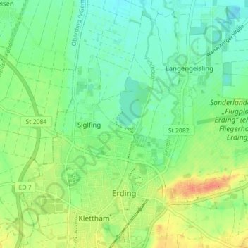
Name: Erding topographic map, elevation, terrain.

Location: Erding, Landkreis Erding, Bavaria, 85435, Germany (48.29610 11.88752 48.34257 11.94212)

Average elevation: 1,509 ft

Minimum elevation: 1,457 ft

Maximum elevation: 1,594 ft

Gear up for your next adventure:

🔌Solar Panel Charger - Charge gear sustainably outdoors
🪑Ultralight Camp Chairs - Portable seating for resting after a long day of mapping
📦Dry Bags Set - Waterproof storage for electronics and clothes
Backpacking Tent - Lightweight and durable tent for multi‑day hikes
🦶Hiking Gaiters - Keep debris and water out of your boots

As an Amazon Associate, this site earns from qualifying purchases at no extra cost to you.