
Errol topographic map
Click on the map to display elevation.
Errol
According to the United States Census Bureau, the town has a total area of 69.5 square miles (179.9 km2), of which 60.3 square miles (156.3 km2) are land and 9.1 square miles (23.5 km2) are water, comprising 13.09% of the town. The Androscoggin River begins in Errol, where the Magalloway River joins the outlet of Umbagog Lake. The town's elevation reaches 2,350 feet (720 m) above sea level atop a bump above Signal Pond near the town's western boundary. Errol lies fully within the Androscoggin River watershed.
About this map
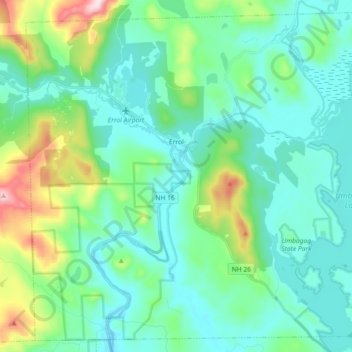
Name: Errol topographic map, elevation, terrain.
Location: Errol, Coös County, New Hampshire, United States (44.70826 -71.21595 44.82871 -71.03441)
Average elevation: 1,486 ft
Minimum elevation: 1,175 ft
Maximum elevation: 2,694 ft
Coos County trails, hiking, mountain biking, running and outdoor activities
Other topographic maps
Click on a map to view its topography, its elevation and its terrain.
Mount Washington
United States > New Hampshire > Coos County
Mount Washington, in New Hampshire, is the highest peak in the Northeastern United States at 6,288.2 ft (1,916.6 m) and the most topographically prominent mountain east of the Mississippi River.
Average elevation: 5,144 ft
Mount Washington
United States > New Hampshire > Coos County
Mount Washington, also known as Agiocochook, is an ultra-prominent mountain in the state of New Hampshire. It is the highest peak in the Northeastern United States at 6,288.2 ft (1,916.6 m) and the most topographically prominent mountain east of the Mississippi River.
Average elevation: 5,144 ft
Mount Adams
United States > New Hampshire > Coos County
Mount Adams, elevation 5,793 feet (1,766 m) above sea level, is a mountain in New Hampshire, the second highest peak in the Northeast United States after its nearby neighbor, Mount Washington. Located in the northern Presidential Range, Mount Adams was named after John Adams, the second President of the United…
Average elevation: 4,524 ft
Mount Washington
United States > New Hampshire > Coos County
Mount Washington, also known as Agiocochook, is an ultra-prominent mountain in the state of New Hampshire. It is the highest peak in the Northeastern United States at 6,288.2 ft (1,916.6 m) and the most topographically prominent mountain east of the Mississippi River.
Average elevation: 5,144 ft
Mount Washington
United States > New Hampshire > Coos County
Mount Washington is an ultra-prominent mountain in the state of New Hampshire. It is the highest peak in the Northeastern United States at 6,288.2 ft (1,916.6 m) and the most topographically prominent mountain east of the Mississippi River.
Average elevation: 5,144 ft
Jefferson Highland
United States > New Hampshire > Coos County > Jefferson
Average elevation: 1,480 ft