
Scotton CP topographic map
Click on the map to display elevation.
About this map
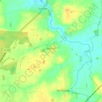
Name: Scotton CP topographic map, elevation, terrain.
Average elevation: 59 ft
Minimum elevation: 20 ft
Maximum elevation: 98 ft
Other topographic maps
Click on a map to view its topography, its elevation and its terrain.
Bishopbridge
United Kingdom > England > Lincolnshire > West Lindsey > Osgodby CP
Average elevation: 33 ft
Caen Hill
United Kingdom > England > Lincolnshire > West Lindsey > Great Limber CP
Average elevation: 272 ft
Rase Park
United Kingdom > England > Lincolnshire > West Lindsey > Market Rasen
Average elevation: 92 ft
Welton Cliff
United Kingdom > England > Lincolnshire > West Lindsey > Welton CP
Average elevation: 174 ft
Limber Hill
United Kingdom > England > Lincolnshire > West Lindsey > Great Limber CP
Average elevation: 148 ft
Gate Burton
United Kingdom > England > Lincolnshire > West Lindsey > Marton > Gate Burton
Average elevation: 43 ft
East Stockwith
United Kingdom > England > Lincolnshire > West Lindsey > East Stockwith
Average elevation: 16 ft
Scotterthorpe
United Kingdom > England > Lincolnshire > West Lindsey > Scotter CP > Scotterthorpe
Average elevation: 39 ft