Geolocate

Gatehead topographic map

Click on the map to display elevation.

About this map

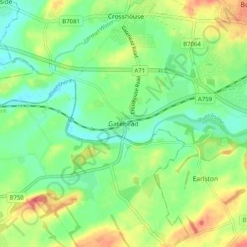
Name: Gatehead topographic map, elevation, terrain.

Location: Gatehead, East Ayrshire, Scotland, KA2 0AN, United Kingdom (55.57477 -4.57344 55.61477 -4.53344)

Average elevation: 105 ft

Minimum elevation: 33 ft

Maximum elevation: 213 ft

Other topographic maps

Click on a map to view its topography, its elevation and its terrain.

Glenbuck Loch

United Kingdom > Scotland > East Ayrshire

Average elevation: 1,073 ft

River Doon

United Kingdom > Scotland > East Ayrshire > Dalrymple

Average elevation: 551 ft

River Ayr

United Kingdom > Scotland > East Ayrshire

Average elevation: 689 ft

Braid Wood

United Kingdom > Scotland > East Ayrshire

Average elevation: 374 ft

Loch Doon

United Kingdom > Scotland > East Ayrshire

Average elevation: 955 ft

Gear up for your next adventure:

🧤Tactile Hiking Gloves - Keep hands warm while operating GPS and smartphone screens
🎒Day Hiking Backpack - Lightweight backpack perfect for day trips and outdoor adventures
📖Nature Tracking Books - Learn to track wildlife and terrain
🪶Fire Starter Kit - Reliable fire starter for survival and camping
🏕️Family Camping Gear - Essentials for group camping trips

As an Amazon Associate, this site earns from qualifying purchases at no extra cost to you.