Geolocate

Colcord topographic map

Click on the map to display elevation.

About this map

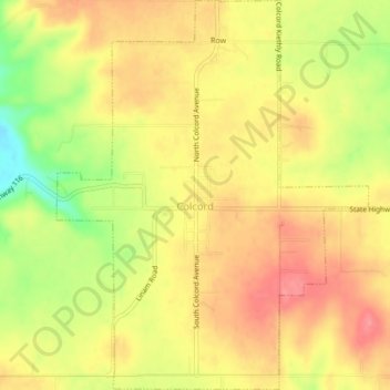
Name: Colcord topographic map, elevation, terrain.

Location: Colcord, Delaware County, Oklahoma, United States (36.24826 -94.70799 36.28218 -94.67427)

Average elevation: 1,138 ft

Minimum elevation: 968 ft

Maximum elevation: 1,240 ft

Delaware County trails, hiking, mountain biking, running and outdoor activities

Other topographic maps

Click on a map to view its topography, its elevation and its terrain.

Chloeta

United States > Oklahoma > Delaware County

Average elevation: 863 ft

Eucha

United States > Oklahoma > Delaware County

Average elevation: 1,024 ft

Kenwood

United States > Oklahoma > Delaware County

Average elevation: 866 ft

Gear up for your next adventure:

🎒Outdoor Daypacks - Lightweight backpacks designed for carrying maps and essential gear
🌲Outdoor Survival Books - Best books on survival skills
🎒Waterproof Dry Bags - Keep your electronics and maps dry inside your pack
🎒Trekking Poles - Sturdy poles for balance and stability on rough terrain
🔥Camping Stove - Portable stove for camping and backcountry cooking

As an Amazon Associate, this site earns from qualifying purchases at no extra cost to you.