
Make a donation
Gear up for your next adventure:
As an Amazon Associate, this site earns from qualifying purchases at no extra cost to you.
Toce / Tosa topographic map
Click on the map to display elevation.
Make a donation
Gear up for your next adventure:
As an Amazon Associate, this site earns from qualifying purchases at no extra cost to you.
About this map
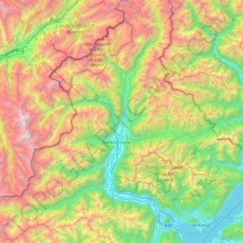
Name: Toce / Tosa topographic map, elevation, terrain.
Location: Toce / Tosa, Piemont, 28866, Italy (45.89436 8.26527 46.42509 8.57654)
Average elevation: 5,144 ft
Minimum elevation: 610 ft
Maximum elevation: 13,081 ft
Make a donation
Gear up for your next adventure:
As an Amazon Associate, this site earns from qualifying purchases at no extra cost to you.
Other topographic maps
Click on a map to view its topography, its elevation and its terrain.
Oasi WWF del Pian dei Sali
Italy > Piemont > Verbano-Cusio-Ossola > Finero
Average elevation: 3,192 ft
Make a donation
Gear up for your next adventure:
As an Amazon Associate, this site earns from qualifying purchases at no extra cost to you.
Make a donation
Gear up for your next adventure:
As an Amazon Associate, this site earns from qualifying purchases at no extra cost to you.
Tetto Battista Massa
Italy > Piemont > Cuneo > Roccavione > Tetto Battista Massa
Average elevation: 2,487 ft
Marmorito Santa Maria
Italy > Piemont > Asti > Aramengo > Marmorito Santa Maria
Average elevation: 1,079 ft
Fubine Monferrato
Italy > Piemont > Alessandria > Fubine Monferrato > Fubine Monferrato
Average elevation: 548 ft
Make a donation
Gear up for your next adventure:
As an Amazon Associate, this site earns from qualifying purchases at no extra cost to you.