Geolocate

Kolbotn topographic map

Click on the map to display elevation.

About this map

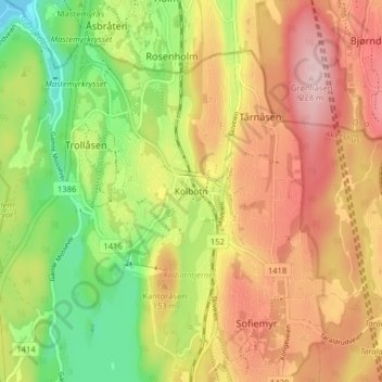
Name: Kolbotn topographic map, elevation, terrain.

Location: Kolbotn, Nordre Follo, Akershus, 1410, Norge (59.79064 10.77991 59.83064 10.81991)

Average elevation: 381 ft

Minimum elevation: 0 ft

Maximum elevation: 738 ft

Other topographic maps

Click on a map to view its topography, its elevation and its terrain.

Lillestrøm

Norge > Akershus

Average elevation: 650 ft

Mosjøen

Norge > Akershus

Average elevation: 837 ft

Østmarka

Norge > Akershus

Average elevation: 528 ft

Asker

Norge > Akershus

Average elevation: 430 ft

Bærum

Norge > Akershus

Average elevation: 666 ft

Nannestad

Norge > Akershus

Average elevation: 1,086 ft

Nesodden

Norge > Akershus

Average elevation: 151 ft

Eidsvoll

Norge > Akershus

Average elevation: 1,112 ft

Nes

Norge > Akershus

Average elevation: 705 ft

Vestby

Norge > Akershus

Average elevation: 223 ft

Gear up for your next adventure:

🔥Camping Stove - Portable stove for camping and backcountry cooking
🪶Trail Camera - Capture wildlife on your hikes
🛌Ultralight Sleeping Bags - Compact down bags for cold nights in the wilderness
📷Action Cameras - Rugged cameras to document your journeys across rugged terrain
📡GPS Antenna Upgrade - Enhance GPS reception in remote terrain

As an Amazon Associate, this site earns from qualifying purchases at no extra cost to you.