Geolocate

Dayton topographic map

Click on the map to display elevation.

About this map

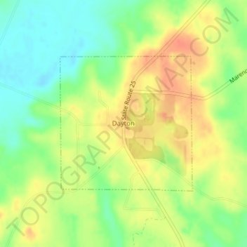
Name: Dayton topographic map, elevation, terrain.

Location: Dayton, Marengo County, Alabama, United States (32.34353 -87.65015 32.35828 -87.63294)

Average elevation: 207 ft

Minimum elevation: 128 ft

Maximum elevation: 279 ft

Marengo County trails, hiking, mountain biking, running and outdoor activities

Other topographic maps

Click on a map to view its topography, its elevation and its terrain.

Hugo

United States > Alabama > Marengo County

Average elevation: 167 ft

Dayton

United States > Alabama > Marengo County

Average elevation: 207 ft

Gear up for your next adventure:

🧭Pro Hiking Compasses - High-accuracy liquid-filled compasses for topographic orientation
🧭Map Reading Tools - Tools and kits for map navigation
🌡️Portable Weather Meter - Track weather conditions on the trail
🗺️Topographic Maps - Detailed topo maps for hiking, exploring and outdoor navigation
🏕️Tent Footprint - Protect your tent base from wear

As an Amazon Associate, this site earns from qualifying purchases at no extra cost to you.