
Dayton topographic map
Click on the map to display elevation.
About this map
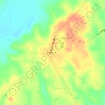
Name: Dayton topographic map, elevation, terrain.
Location: Dayton, Marengo County, Alabama, United States (32.34353 -87.65015 32.35828 -87.63294)
Average elevation: 207 ft
Minimum elevation: 128 ft
Maximum elevation: 279 ft
Marengo County trails, hiking, mountain biking, running and outdoor activities
Other topographic maps
Click on a map to view its topography, its elevation and its terrain.
Faunsdale
United States > Alabama > Marengo County
Faunsdale is located at 32°27′33″N 87°35′36″W / 32.45917°N 87.59333°W / 32.45917; -87.59333. According to the U.S. Census Bureau, the town has a total area of 0.2 square miles (0.52 km2), all land. The elevation is 220 feet (67 m).
Average elevation: 203 ft
Sweet Water
United States > Alabama > Marengo County
Sweet Water is located in southern Marengo County at 32°05′51″N 87°52′03″W / 32.09737°N 87.86751°W / 32.09737; -87.86751 and has an elevation of 184 feet (56 m). It is 20 miles (32 km) by road south of Linden, the county seat. Alabama State Route 10 passes through the town, leading…
Average elevation: 200 ft