Geolocate

Carlisle topographic map

Click on the map to display elevation.

About this map

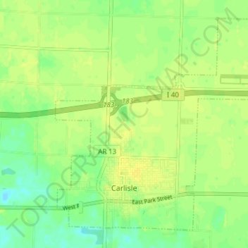
Name: Carlisle topographic map, elevation, terrain.

Location: Carlisle, Lonoke County, Arkansas, United States (34.77444 -91.76375 34.81791 -91.70192)

Average elevation: 236 ft

Minimum elevation: 200 ft

Maximum elevation: 256 ft

Lonoke County trails, hiking, mountain biking, running and outdoor activities

Other topographic maps

Click on a map to view its topography, its elevation and its terrain.

Summit Addition

United States > Arkansas > Lonoke County > Cabot

Average elevation: 338 ft

Furlow

United States > Arkansas > Lonoke County

Average elevation: 259 ft

Gear up for your next adventure:

🎒Trekking Poles - Sturdy poles for balance and stability on rough terrain
🗺️Topographic Maps - Detailed topo maps for hiking, exploring and outdoor navigation
📚Navigation Handbooks - Master the art of reading topographic maps and using a compass
🗃️Trail First Aid Kit - Essential kit for outdoor injuries and emergencies
🧦Merino Wool Socks - Moisture-wicking, blister-preventing socks for long treks

As an Amazon Associate, this site earns from qualifying purchases at no extra cost to you.