Geolocate

Hojai topographic map

Click on the map to display elevation.

About this map

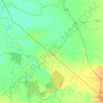
Name: Hojai topographic map, elevation, terrain.

Location: Hojai, Assam, 782435, India (25.90907 92.73311 26.10897 92.92571)

Average elevation: 233 ft

Minimum elevation: 197 ft

Maximum elevation: 289 ft

Other topographic maps

Click on a map to view its topography, its elevation and its terrain.

Jorabat

India > Assam > Sonapur

Average elevation: 499 ft

Diphu

India > Assam > Diphu

Diphu is located at 25°50′N 93°26′E / 25.83°N 93.43°E / 25.83; 93.43. It has an average elevation of 186 metres (610 feet). It is about 270 km by road and 213 km by railways from Guwahati. The town is located on a beautiful hill.

Average elevation: 630 ft

Tezpur

India > Assam > Tezpur

Average elevation: 223 ft

Subansiri

India > Assam > Gogamukh

Average elevation: 315 ft

Kāmrūp

India > Assam

Average elevation: 1,083 ft

Badarpur

India > Assam > Badarpur > Badarpur

Average elevation: 89 ft

Numaligarh

India > Assam > Bokakhat > Numaligarh

Average elevation: 285 ft

Gear up for your next adventure:

🌲Outdoor Survival Books - Best books on survival skills
🎒Outdoor Daypacks - Lightweight backpacks designed for carrying maps and essential gear
🔥Plasma Lighters - Windproof lighters that work in any weather condition
📱Heavy-Duty Phone Cases - Drop-proof and waterproof protection for outdoor navigation
🧭GPS Watch Accessories - Bands and chargers for GPS watches

As an Amazon Associate, this site earns from qualifying purchases at no extra cost to you.