
Make a donation
Gear up for your next adventure:
As an Amazon Associate, this site earns from qualifying purchases at no extra cost to you.
Koyilandy topographic map
Click on the map to display elevation.
Make a donation
Gear up for your next adventure:
As an Amazon Associate, this site earns from qualifying purchases at no extra cost to you.
Koyilandy
Koyilandy is located at 11°26′N 75°42′E / 11.43°N 75.70°E / 11.43; 75.70 at an average elevation of 2 m (6.6 ft).
Make a donation
Gear up for your next adventure:
As an Amazon Associate, this site earns from qualifying purchases at no extra cost to you.
About this map
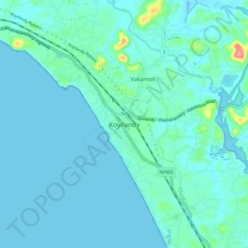
Name: Koyilandy topographic map, elevation, terrain.
Location: Koyilandy, Koyilandi, Kozhikode, Kerala, 673300, India (11.39836 75.65689 11.47836 75.73689)
Average elevation: 30 ft
Minimum elevation: -7 ft
Maximum elevation: 276 ft
Make a donation
Gear up for your next adventure:
As an Amazon Associate, this site earns from qualifying purchases at no extra cost to you.
Other topographic maps
Click on a map to view its topography, its elevation and its terrain.
Alangattu Vettkkoru makan kshethra Kulam at Cheliya
Average elevation: 43 ft
Make a donation
Gear up for your next adventure:
As an Amazon Associate, this site earns from qualifying purchases at no extra cost to you.
Make a donation
Gear up for your next adventure:
As an Amazon Associate, this site earns from qualifying purchases at no extra cost to you.