Geolocate

Forney topographic map

Click on the map to display elevation.

About this map

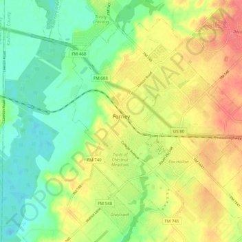
Name: Forney topographic map, elevation, terrain.

Location: Forney, Kaufman County, Texas, 75126, United States (32.70560 -96.49617 32.78681 -96.39815)

Average elevation: 446 ft

Minimum elevation: 354 ft

Maximum elevation: 554 ft

Kaufman County trails, hiking, mountain biking, running and outdoor activities

Other topographic maps

Click on a map to view its topography, its elevation and its terrain.

Poetry

United States > Texas > Kaufman County

Average elevation: 554 ft

Gastonia

United States > Texas > Kaufman County > Gastonia

Average elevation: 440 ft

Gear up for your next adventure:

⛑️Personal Locator Beacon - Safety beacon for emergencies
🧷Carabiner Set - Durable clips for gear attachment
📶Vehicle Signal Boosters - Improve reception in rural areas while driving to trailheads
🧭Outdoor Navigation Book - Learn advanced navigation skills
🥇GPS Hiking Watch - Multi‑sport GPS watch with navigation and trail tracking

As an Amazon Associate, this site earns from qualifying purchases at no extra cost to you.