
Make a donation
Gear up for your next adventure:
As an Amazon Associate, this site earns from qualifying purchases at no extra cost to you.
Bear Valley topographic map
Click on the map to display elevation.
Make a donation
Gear up for your next adventure:
As an Amazon Associate, this site earns from qualifying purchases at no extra cost to you.
Bear Valley
Bear Valley's central Sierra location and elevation gives it a warm-summer Mediterranean climate that is nearly a subarctic climate. Precipitation is seen for a lot of the year except for the middle of the summer, which can experience rare, but not unseen, thunderstorms. Late fall to early spring brings in most of the yearly precipitation, typically in the form of abundant snowfall. Furthermore, summers are warm with cool nights while winters are cold and relatively long.
Make a donation
Gear up for your next adventure:
As an Amazon Associate, this site earns from qualifying purchases at no extra cost to you.
About this map
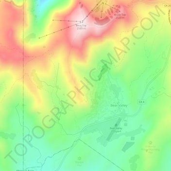
Name: Bear Valley topographic map, elevation, terrain.
Location: Bear Valley, Alpine County, California, United States (38.44711 -120.07260 38.49274 -120.01916)
Average elevation: 7,480 ft
Minimum elevation: 6,696 ft
Maximum elevation: 8,488 ft
Alpine County trails, hiking, mountain biking, running and outdoor activities
Make a donation
Gear up for your next adventure:
As an Amazon Associate, this site earns from qualifying purchases at no extra cost to you.
Other topographic maps
Click on a map to view its topography, its elevation and its terrain.
Make a donation
Gear up for your next adventure:
As an Amazon Associate, this site earns from qualifying purchases at no extra cost to you.