Geolocate

Adolph topographic map

Click on the map to display elevation.

About this map

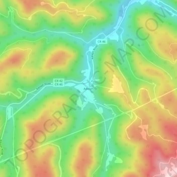
Name: Adolph topographic map, elevation, terrain.

Location: Adolph, Randolph County, West Virginia, 26280, United States (38.72455 -80.06563 38.76455 -80.02563)

Average elevation: 2,694 ft

Minimum elevation: 2,221 ft

Maximum elevation: 3,310 ft

Randolph County trails, hiking, mountain biking, running and outdoor activities

Other topographic maps

Click on a map to view its topography, its elevation and its terrain.

Montrose

United States > West Virginia > Randolph County

Average elevation: 2,067 ft

Gear up for your next adventure:

🧢Outdoor Hiking Hat - Sun protection hat for outdoor explorers
🧯Portable Fire Pit - Compact fire pit for camping spots
🖼️Topo Map Wall Art - Decorative topographic prints of famous peaks and regions
🧤Tactile Hiking Gloves - Keep hands warm while operating GPS and smartphone screens
🪑Portable Camp Table - Compact table for campsite meals

As an Amazon Associate, this site earns from qualifying purchases at no extra cost to you.