
Make a donation
Gear up for your next adventure:
As an Amazon Associate, this site earns from qualifying purchases at no extra cost to you.
Kumbrabow State Forest topographic map
Click on the map to display elevation.
Make a donation
Gear up for your next adventure:
As an Amazon Associate, this site earns from qualifying purchases at no extra cost to you.
About this map
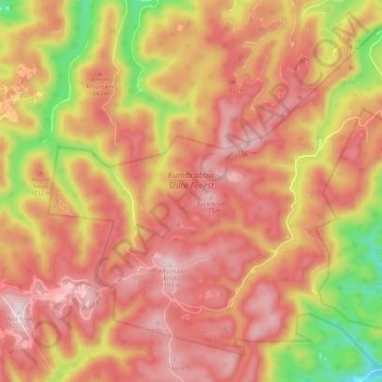
Name: Kumbrabow State Forest topographic map, elevation, terrain.
Average elevation: 3,323 ft
Minimum elevation: 2,270 ft
Maximum elevation: 3,953 ft
Randolph County trails, hiking, mountain biking, running and outdoor activities
Make a donation
Gear up for your next adventure:
As an Amazon Associate, this site earns from qualifying purchases at no extra cost to you.
Other topographic maps
Click on a map to view its topography, its elevation and its terrain.
Make a donation
Gear up for your next adventure:
As an Amazon Associate, this site earns from qualifying purchases at no extra cost to you.
Bickle Knob
United States > West Virginia > Randolph County
Bickle Knob is located at the end of Forest Route 91A, a spur from Stuart Memorial Drive (FR 91). Both roads are gravel but can easily be traversed by normal passenger cars. Stuart Memorial Drive is a scenic path as it traces the edge of the Shavers Fork canyon. Due to the high elevation of the area and the…
Average elevation: 3,222 ft
Make a donation
Gear up for your next adventure:
As an Amazon Associate, this site earns from qualifying purchases at no extra cost to you.