Geolocate

New London topographic map

Click on the map to display elevation.

About this map

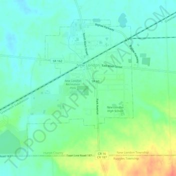
Name: New London topographic map, elevation, terrain.

Location: New London, New London Township, Huron County, Ohio, United States (41.06538 -82.43717 41.09477 -82.38702)

Average elevation: 997 ft

Minimum elevation: 948 ft

Maximum elevation: 1,109 ft

Huron County trails, hiking, mountain biking, running and outdoor activities

Other topographic maps

Click on a map to view its topography, its elevation and its terrain.

Delphi

United States > Ohio > Huron County

Average elevation: 1,030 ft

New Haven

United States > Ohio > Huron County

Average elevation: 942 ft

Boughtonville

United States > Ohio > Huron County

Average elevation: 994 ft

Centerton

United States > Ohio > Huron County

Average elevation: 883 ft

East Townsend

United States > Ohio > Huron County

Average elevation: 892 ft

Fitchville

United States > Ohio > Huron County

Average elevation: 978 ft

Hunts Corners

United States > Ohio > Huron County

Average elevation: 771 ft

Olena

United States > Ohio > Huron County

Average elevation: 948 ft

Steuben

United States > Ohio > Huron County

Average elevation: 863 ft

Huron Junction

United States > Ohio > Huron County > Norwalk

Average elevation: 758 ft

Collins

United States > Ohio > Huron County

Average elevation: 876 ft

Gear up for your next adventure:

📷Action Camera - Capture your outdoor adventures in HD
🥩Freeze-Dried Meals - Nutritious and lightweight food for remote expeditions
🎒Outdoor Daypacks - Lightweight backpacks designed for carrying maps and essential gear
🏔️Mountain Trail Maps - High‑detail maps for popular peaks
🕶️Glacier Sunglasses - Side shields to protect eyes from high-altitude snow glare

As an Amazon Associate, this site earns from qualifying purchases at no extra cost to you.