
Ligneuville topographic map
Interactive map
Click on the map to display elevation.
About this map
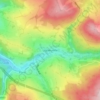
Name: Ligneuville topographic map, elevation, terrain.
Location: Ligneuville, Malmedy, Verviers, Liège, Wallonie, 4960, Belgique (50.35572 6.03493 50.39572 6.07493)
Average elevation: 1,434 ft
Minimum elevation: 1,070 ft
Maximum elevation: 1,854 ft
Other topographic maps
Click on a map to view its topography, its elevation and its terrain.
Lamonriville
Belgique > Liège > Verviers > Malmedy
Lamonriville, Malmedy, Verviers, Liège, Wallonie, 4960, Belgique
Average elevation: 1,401 ft