
Miramar topographic map
Click on the map to display elevation.
About this map
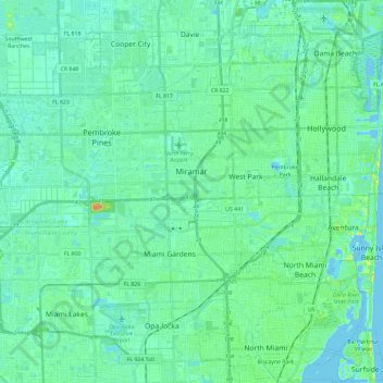
Name: Miramar topographic map, elevation, terrain.
Location: Miramar, Broward County, Florida, 33023, United States (25.95684 -80.44063 25.99541 -80.20612)
Average elevation: 20 ft
Minimum elevation: -10 ft
Maximum elevation: 98 ft
Broward County trails, hiking, mountain biking, running and outdoor activities
Other topographic maps
Click on a map to view its topography, its elevation and its terrain.
Lauderdale Harbors
United States > Florida > Broward County > Fort Lauderdale
Average elevation: 20 ft
Ro-Len Lake Gardens
United States > Florida > Broward County > Hallandale Beach
Average elevation: 23 ft
Chapel Trail Nature Preserve
United States > Florida > Broward County > Pembroke Pines
Average elevation: 13 ft
Middle River Vista
United States > Florida > Broward County > Fort Lauderdale
Average elevation: 23 ft
Bonita Bay
United States > Florida > Broward County > Fort Lauderdale > Soroka Shores
Average elevation: 13 ft
Lauderdale Harbors
United States > Florida > Broward County > Fort Lauderdale
Average elevation: 20 ft
Lauderdale Harbors
United States > Florida > Broward County > Fort Lauderdale
Average elevation: 20 ft
Bonita Bay
United States > Florida > Broward County > Fort Lauderdale > Soroka Shores
Average elevation: 13 ft
Cypress Isles Estates
United States > Florida > Broward County > Pompano Beach
Average elevation: 20 ft
Fort Lauderdale Beach
United States > Florida > Broward County > Fort Lauderdale > Birch Ocean Front
Average elevation: 10 ft