
Make a donation
Gear up for your next adventure:
As an Amazon Associate, this site earns from qualifying purchases at no extra cost to you.
São Paulo topographic map
Click on the map to display elevation.
Make a donation
Gear up for your next adventure:
As an Amazon Associate, this site earns from qualifying purchases at no extra cost to you.
São Paulo
The city is on a plateau placed beyond the Serra do Mar (Portuguese for "Sea Range" or "Coastal Range"), itself a component of the vast region known as the Brazilian Highlands, with an average elevation of around 799 meters (2,621 ft) above sea level, although being at a distance of only about 70 kilometers (43 mi) from the Atlantic Ocean. The distance is covered by two highways, the Anchieta and the Imigrantes, (see "Transportation" below) that roll down the range, leading to the port city of Santos and the beach resort of Guarujá. Rolling terrain prevails within the urbanized areas of São Paulo except in its northern area, where the Serra da Cantareira Range reaches a higher elevation and a sizable remnant of the Atlantic Rain Forest. The region is seismically stable and no significant activity has ever been recorded.
Make a donation
Gear up for your next adventure:
As an Amazon Associate, this site earns from qualifying purchases at no extra cost to you.
About this map
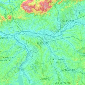
Name: São Paulo topographic map, elevation, terrain.
Average elevation: 2,575 ft
Minimum elevation: 2,323 ft
Maximum elevation: 3,937 ft
Make a donation
Gear up for your next adventure:
As an Amazon Associate, this site earns from qualifying purchases at no extra cost to you.
Other topographic maps
Click on a map to view its topography, its elevation and its terrain.
Embu-Guaçu
Brazil > São Paulo > Região Metropolitana de São Paulo
Embu-Guaçu is a municipality in the state of São Paulo in Brazil. It is part of the Metropolitan Region of São Paulo. The population is 69,901 (2020 est.) in an area of 155.64 km2. The elevation is 408 m.
Average elevation: 2,589 ft
Mauá
Brazil > São Paulo > Região Metropolitana de São Paulo
The city has a special characteristic hydrographic: not be crossed by any water course from another city, since, due to the high altitude, all streams that cross the territory of Mauá has their sources inside the city limits.
Average elevation: 2,641 ft
Ribeirão Pires
Brazil > São Paulo > Região Metropolitana de São Paulo
Ribeirão Pires (Pires Stream) is a city in the Metropolitan Region of the city of São Paulo, in the state of São Paulo, Brazil. It is part of the "ABC Region." The population is 124,159 (2020 est.) in an area of 99.1 km2. The elevation is 763 m.
Average elevation: 2,621 ft
Make a donation
Gear up for your next adventure:
As an Amazon Associate, this site earns from qualifying purchases at no extra cost to you.
Cotia
Brazil > São Paulo > Região Metropolitana de São Paulo
Cotia is a municipality in the state of São Paulo in Brazil. It is part of the Metropolitan Region of São Paulo. The population is 253,608 (2020 est.) in an area of 323.99 km2. The city is at an elevation of 853 m. Cotia is linked with the Rodovia Raposo Tavares highway.
Average elevation: 2,818 ft
Butantã
Brazil > São Paulo > Região Metropolitana de São Paulo > São Paulo
Average elevation: 2,451 ft